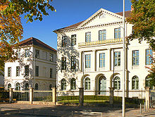
Friedrichswall
The Friedrichswall is a street in Hanover . It was originally called Friedrichstrasse and was named after Friedrich, Duke of York and Albany . Today, the road has been developed as a main thoroughfare with four to six lanes and leads over the southern course of the former city fortifications of Hanover .
history

When the city fortifications of Hanover still existed, the "Nothelfergraben" ran in the area of the Friedrichswall. It was the widest part of the moat between the former Aegidientor windmill bastion and the Kingdom of Heaven bastion. To the south of the wall in front of it was the lowland area of the Aegidienmasch.
From around 1779–83 / 84, the area around Friedrichswall was rebuilt in the course of the demolition according to plans by Georg Josua du Plat and Georg Christoph Müller. By flattening the wall, building sites were gained, and an avenue created the ambience for a promenade. The “Am Himmelreich” and “Mühlenplatz” squares formed semicircular transitions into the old town. The medieval city fortifications on the “Blue Thunder” were broken through between these places; a "new way" (after 1783) created the connection to the Leinstraße.
Early development
Between 1798 and 1842, the town's granary was located on the western square of the promenade. On the city side, an initially loose, then compact development with villas and residential houses arose until 1822. A clubhouse was built at the west end and a billiards club at the east end.
On the field side (western half) the council chamber square was initially created, otherwise there were meadows and gardens. Christian Schaumburg redesigned this area around 1830 : A narrow landscape park with a “flower basket” was created in front of the Neuer Weg along the reduced Nothelfergraben.
Public buildings were then erected on the edge of this park (all of which had disappeared by 1945):
- In 1829 a "Russian steam bath" opened.
- From 1855/56 Angerstein's pump room offered liquids.
- Hanover's first indoor swimming pool was built in 1867.
Bourgeois buildings
In 1879, the architect Christoph Hehl built the residential and commercial building for Karl Friedrich Wunder , son of the first and most famous Hanoverian photographer of the 19th century, Friedrich Karl Wunder, in the previously almost purely aristocratic street .
Today's development

The view of the lowlands of the Aegidienmasch was only closed later by large urban buildings:
- 1889 Museum August Kestner
- 1906 Municipal Building Authority (destroyed in World War II)
- 1913 New Town Hall
The machine park facility made up for the lost view.
In 1891 there was an additional breakthrough from the promenade to the old town with the construction of Ebhardtstraße. While the villa development increasingly came into municipal ownership, Friedrichstrasse had a quiet and elegant character until 1945 due to the lack of access.
In 1919/22, city planning officer Paul Wolfs presented a plan for topic-related “city forums”, according to which Friedrichstrasse (from west to east) was to be developed into forums for welfare, art and administration.
After the former promenade was renamed Friedrichswall, the street was converted from 1952 to 1961 into part of the tangent ring around the city center and became the main thoroughfare. Its course led over areas of the war-torn Aegidienneustadt to Aegidientorplatz . The concept of the redesign included a number of open architectural spaces. They should deliberately contain a strong contrast between old and new buildings. The Friedrichswall became the transition from the government district to the city center. At the same time it was the interface to the recreational landscape of the Leineaue.
Today the Friedrichswall is the only area of Hanover in which the boundaries of the closed development have hardly moved out of town for centuries.

Of the older buildings, only the following buildings have survived:
- Wangenheimpalais (house number 1)
- Laves House (No. 5)
- Wonder House (No. 17)
Today the following are dominant:
- Maritim Hotel (No. 11)
- new town hall
- Nord / LB administration building (No. 10) as a superstructure on the rest of the eastern part of the old Friedrichstrasse
literature
- Birgit Graff: "For Karl, long and compulsory work would be appropriate soon." The welfare office at Friedrichstrasse 17 , in Adelheid von Saldern et al. : Everyday life between Hindenburg and Haarmann. Another city guide through Hanover in the 20s , publisher: Geschichtswerkstatt Hannover, Hamburg: VSA-Verlag, 1987, ISBN 3-87975-397-0 , pp. 99-104
- Günther Kokkelink , Harold Hammer-Schenk (eds.): Laves and Hannover. Lower Saxony architecture in the 19th century . Hanover 1999, p. 245 f.
- Unbuilt Hanover. 1991, p. 34 f.
- Helmut Knocke , Hugo Thielen : Friedrichswall. In: Hannover Art and Culture Lexicon , p. 112ff. u.ö.
- Helmut Knocke: Friedrichstrasse. In: Klaus Mlynek, Waldemar R. Röhrbein (eds.) U. a .: City Lexicon Hanover . From the beginning to the present. Schlütersche, Hannover 2009, ISBN 978-3-89993-662-9 , p. 196.
Web links
Individual evidence
- ^ Ludwig Hoerner In: Hanover in early photographs 1848–1910. With a contribution by Franz Rudolf Zankl. Schirmer-Mosel, Munich 1979, ISBN 3-921375-44-4 , p. 37f.
- ↑ Gerd Weiß (together with Marianne Zehnpfennig): The southern ramparts: Friedrichswall. In: Monument topography Federal Republic of Germany , architectural monuments in Lower Saxony, City of Hanover, Part 1 , Vol. 10.1, published by the Lower Saxony State Administration Office - Institute for Monument Preservation, Friedr. Vieweg & Sohn, Braunschweig / Wiesbaden 1983, ISBN 3-528-06203-7 , p. 66f.
Coordinates: 52 ° 22 ′ 5.5 ″ N , 9 ° 44 ′ 19 ″ E

