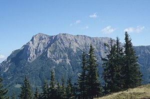
Gßeck
| Gßeck | ||
|---|---|---|
| height | 2214 m above sea level A. | |
| location | Styria , Austria | |
| Mountains | Eisenerzer Alps , Ennstal Alps | |
| Dominance | 16 km → Seckauer Zinken | |
| Notch height | 832 m ↓ Hoheneck | |
| Coordinates | 47 ° 26 '55 " N , 14 ° 53' 58" E | |
|
|
||
| rock | Old Paleozoic Limestone | |
| Age of the rock | Paleozoic | |
The Gßeck is at 2214 m above sea level. A. the highest peak in the Eisenerzer Alps . It is in front of the approximately 30 km long main ridge (with Eisenerzer Reichenstein 2165 m ) in the south and forms with its secondary peaks the mountain range of the Reiting .
The majority of the Eisenerzer Alps is geologically assigned to the Grauwackenzone , although as part of the Ennstal Alps they belong to the Northern Limestone Alps . The zone of the old Grauwacken rocks reaches its greatest width here, between the mining towns of Eisenerz and Leoben , at 10–15 km.
On the north side of the Gößeck just below the summit there is a memorial stone to the helicopter crash on April 15, 1986.

