Eisenerzer Reichenstein
| Eisenerzer Reichenstein | ||
|---|---|---|
|
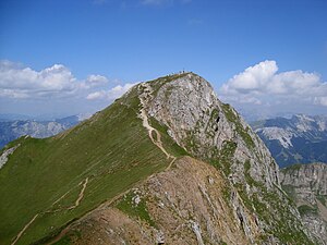
Northeast summit of the Eisenerzer Reichenstein, seen from the Reichensteinhütte |
||
| height | 2165 m above sea level A. | |
| location | Styria , Austria | |
| Mountains | Eisenerzer Alps , Ennstal Alps | |
| Dominance | 6.5 km → Gßeck | |
| Notch height | 660 m ↓ Treffneralm | |
| Coordinates | 47 ° 30 '10 " N , 14 ° 56' 3" E | |
|
|
||
| rock | lime | |
| Age of the rock | Devon | |
| Normal way | From the Präbichl over the Rösselhals | |
The Eisenerzer Reichenstein is a mountain in the Eisenerzer Alps in the Austrian state of Styria . It is located south of the Styrian Erzberg near the town of Eisenerz .
topography
The highest point of the Eisenerzer Reichenstein is the northeast peak with a height of 2165 m above sea level. A. The Reichensteinhütte ( 2136 m ) of the Leoben section of the Austrian Alpine Association is located on a knoll, 270 meters southwest of the summit . From here, a plateau about 250 meters wide and 500 meters long stretches towards the southwest, at the end of which there is another elevation ( 2143 m ).
Further secondary peaks are the Rössel ( 1855 m ) to the north . To the northeast and southeast of the Reichenstein main summit are the Grüblzinken ( 1990 m ), which is separated from the Reichenstein by the Rottörl , and the Vordernberger Zinken . Only the lower south-east summit ( 1971 m ) of the Vordernberger Zine is listed on the Austrian federal map, but the north-west summit towers above it by at least 30 meters. The ridge west of the Reichenstein carries the elevations Hieflerkogel , Hocheller and Hohe Lins ( 2028 m ). The small Krumpensee ( 1416 m ) is located in a basin south of the Reichenstein .
geology
The Eisenerzer Reichenstein belongs to the Grauwackenzone and consists of Paleozoic rocks. The mountain is largely made up of Devonian limestone .
ways
The shortest way to the Eisenerzer Reichenstein leads from the Präbichl over the Rösselhals to the summit in about two and a half hours. A bit above the Rösselhals you can decide whether to follow the normal route, the Theklasteig , or take a shortcut via a steeper route and four successive ladders, the stairs .
From the Hirnalm near Trofaiach the Grete-Klinger-Steig leads over the Vordernberger Mauer , the Vordernberger Zinken and past the Grüblzinken up to the Rottörl. This trail offers a combination of a long ridge hike with moderately difficult via ferrata sections. The climb is named after Grete Klinger, who died in 1972, in memory of her services to the establishment and youth work in the Trofaiach section of the Alpine Club . The Reichensteinhütte is also the starting point of a very long ridge hike, which leads from Eisenerzer Reichenstein about 40 kilometers to the Mödlinger Hütte at the foot of the Admonter Reichenstein .
Ski touring
The Eisenerzer Reichenstein and its side peaks offer numerous possibilities for ski tours, which however require avalanche-proof conditions, this is especially true for the climbs from the Präbichl. You can ski down from the Reichensteinhals , which is the gap between the south-west summit and the Hieflerkogel , to the Krumpensee. To get back to the Präbichl from here, however, you have to accept 400 meters of ascent to the Rottörl. The demanding ski run from Reichenstein through the Rote Rinne offers a challenge for extreme sports enthusiasts .
Web links
swell
- ↑ Hans Peter Schönlaub: Geological thematic map of the Republic of Austria. Eisenerzer Alps (Grauwackenzone) 1: 25,000 , Federal Geological Institute, Vienna 1981.
- ↑ Bergstieg.com: Grete-Klinger-Steig ( page no longer available , search in web archives ) Info: The link was automatically marked as defective. Please check the link according to the instructions and then remove this notice.
- ^ Hermann Scharfetter, Liselotte Buchenauer : Eisenerzer Alpen, mountain hiking, climbing, Schifahren Verlag Styria, Graz 1978, ISBN 3-222-11096-4 , p. 128.
- ↑ Helmut Prevedel: Schitourenführer Steiermark, over 500 tours, 2nd edition, Verlag Styria, Graz 1995, ISBN 3-222-12352-7 , pp. 64–68.


