
Admonter Reichenstein
| Admonter Reichenstein | ||
|---|---|---|
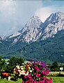
 View from the southeast of the Admonter Reichenstein, to the right of the main summit the Totenköpfl. In the foreground the Mödlinger Hütte |
||
| height | 2251 m above sea level A. | |
| location | Gesäuse , Austria , Styria | |
| Mountains | Ennstal Alps | |
| Dominance | 5.2 km → Großer Ödstein | |
| Notch height | 812 m ↓ Neuburgsattel | |
| Coordinates | 47 ° 32 '57 " N , 14 ° 32' 36" E | |
|
||
| Type | Felsberg | |
| rock | Dachstein - reef limestone | |
| Age of the rock | Trias , Nor | |
| First ascent | On July 23, 1873 by J. Frischauf , F. v. Juraschek with M. Spreitz | |
| Normal way | From the Mödlinger Hütte through the southern gorge | |

The Admonter Reichenstein is a mountain in the Ennstal Alps and the highest and most easterly mountain in the Reichenstein group . Climbing the mountain requires at least grade II climbing .
topography
The Admonter Reichenstein has three peaks, these are from west to east the Admonter Horn 2184 m , the Reichensteingipfel 2251 m above sea level. A. and the Totenköpfl 2178 m . The Admonter Horn is separated from the main summit by the Reichensteinsattel 2170 m . The Totenköpfl is separated from the Reichenstein summit by the Reichensteinscharte 2100 m . The mountain is surrounded on all sides by steep walls and breaks. The Reichenstein is separated from the Sparafeld in the west by the Wildscharte at 1903 m .
Ascents
The normal route to the Reichenstein leads from the Mödlinger Hütte on a steep path to the Herzmann-Kupfer-Kreuz , before it crosses partially over Plattenschüsse ( Herzmann-Kupfer-Platte ) in the area of the southern gorge below the Reichensteinscharte. The further ascent takes place first through this gorge and then over Schrofen, before crossing the south ridge and finally climbing over easy Schrofen terrain to the summit cross. The crossing of a slab and a short vertical point in the gorge require climbing in the second degree . The Totenköpfl can be reached in a short climb from the Reichensteinscharte, one point is in the lower III. Degree.
In addition to the normal route, the Reichenstein offers an abundance of climbing routes of various difficulties, including the south ridge (one point IV, otherwise easier), the west ridge (III, brittle), or the north-east pillar (VI-, V +). Another climbing tour on the Reichenstein leads over the east ridge to the Totenköpfl (III), here you rappel down into the Reichensteinscharte, and then climb through the Reichenstein east face (mostly I-II, max. III, but very vulnerable to falling rocks) almost directly under the summit cross .
geology
Like the Sparafeld and Kalbling , the summit of the Admonter Reichenstein is made of Dachstein limestone , which, in contrast to the Hochtor group, is hardly banked here because it is reef limestone . On the north side of the Reichenstein you can see the original sequence from the Dachstein limestone over the Raibler layers , Ramsaudolomit and Werfen layers . On the south side, this sequence is cut off by a disturbance . The Werfen strata are almost completely absent here and the Paleozoic rocks of the Grauwackenzone immediately follow .

The Admonter Reichenstein with Totenköpfl, Reichenstein-Hauptgipfel and Admonter Horn from the Ennsbrücke near Gstatterboden. To the right of the Reichenstein is the Sparafeld.
View from Weng in south direction to Admonter Reichenstein (left) and Sparafeld (right)

View from the southeast of the Reichenstein group. On the right the Admonter Reichenstein, on the right of the main summit the Totenköpfl, on the left of the Reichenstein the Sparafeld and on the far left the Kalbling. In the foreground the Mödlinger Hütte

The Herzmann copper plate. The crossing of this plate is one of the key points on the normal route.


Individual evidence
- ↑ Willi End : Gesäuseberge. A guide for valleys, huts and mountains (= Alpine Club Guide. Nördliche Kalkalpen series. ). Bergverlag Rudolf Rother, Munich 1988, ISBN 3-7633-1248-X , p. 533 ff.
- ↑ Willi End: Gesäuseberge. A guide for valleys, huts and mountains (= Alpine Club Guide. Nördliche Kalkalpen series. ). Bergverlag Rudolf Rother, Munich 1988, ISBN 3-7633-1248-X , p. 29.