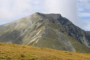
Seckauer Zinken
| Seckauer Zinken | ||
|---|---|---|
|
Seckauer Zinken from the northeast |
||
| height | 2397 m above sea level A. | |
| location | Styria , Austria | |
| Mountains | Seckauer Tauern , Lower Tauern | |
| Dominance | 5 km → Hochreichart | |
| Notch height | 377 m ↓ Brandstättertörl | |
| Coordinates | 47 ° 20 '21 " N , 14 ° 44' 10" E | |
|
|
||
| rock | Gneiss | |
|
The Seckauer Zinken |
||
The Seckauer Zinken is 2397 m above sea level. A. high mountain of the Niedere Tauern in Upper Styria .
Location, character and name of the mountain
The Seckauer Zinken is part of the Seckauer Tauern , the easternmost subgroup of the Niedere Tauern. It rises 8 kilometers north-northwest of the market town of Seckau with its famous Benedictine abbey . The border between the municipalities of Gaal and Mautern in Styria runs over its summit, which also forms the border between the political districts of Murtal and Leoben .
The Seckauer Zinken is not the highest mountain in the Seckauer Tauern, but its most famous peak. Because it is easier to reach, it is also visited more often than Hochreichhart and Geierhaupt .
The spacious summit region of the Seckauer Zinkens slopes comparatively gently to the west and south. The northeast ridge and especially the rocky north flank to the Zinkenschütt , on the other hand, are much steeper. From this perspective, the name "Zinken" becomes plausible, as it refers to rugged shapes.
Due to its free-standing position far to the east of the Niedere Tauern and its height, the Seckauer Zinken offers a comprehensive panorama, with a particularly impressive view of the Gesäuse peaks in the north.
Climbs
Since the side valleys south of the Seckauer Tauern are closed to general traffic and there are no refuges in the summit region, a tour on the Seckauer Zinken requires sufficient time. At the same time, the region was able to retain a lot of naturalness and tranquility.
- The standard ascent from the south begins at Gasthof Steinmühle , 2 kilometers west of Seckau. In the long Zinkengraben initially rising gently, later steeper over a few terrain steps into the wide cirque east of the Seckauer Zinkens with the Goldlacke , a small mountain lake at 1958 m above sea level. A. Again steeply on a ridge and finally over the flat southeast slope to the summit. Walking time: 4 to 4½ hours.
- Another ascent from the east-northeast begins at the Untere Bodenhütte in the uppermost Feistritzgraben (easily managed in summer and accessible ). First through the forest to the alpine pasture of the Weinmeisterboden , then through extensive pine fields to a saddle just northwest of the Hämmerkogel (detour to the summit recommended) and finally over the northeast ridge to the Seckauer Zinken. This route is shorter than the south ascent, but requires surefootedness on the steep northeast ridge. Walking time: around 3 hours.
The panoramic high- altitude hike from the Hochalm with the Maria Schnee pilgrimage church over the main ridge of the Seckauer Tauern to the Seckauer Zinken is very rewarding . Walking time: about 3 hours; a short exposed spot south of the Hämmerkogel.
The continuation of the ridge trail from Seckauer Zinken to the west-northwest leads over the Maierangerkogel and Brandstätterkogel to Hochreichhart , walking time: 3 to 3½ hours.
From the south, the Seckauer Zinken is a popular destination for ski tours , which due to the altitude are often possible well into spring. The route does not follow the summer path, but the long south channel.
literature
- Peter Holl: Alpine Club Guide Niedere Tauern , Bergverlag Rother , Munich 2005, 7th edition ISBN 3-7633-1267-6 , p. OA
- Adi Mokrejs, Max Ostermayer: Bergwander-Atlas Steiermark , Schall-Verlag, Alland 2009. ISBN 978-3-900533-57-1 , p. OA
- K. Schittengruber: The vegetation of the Seckauer Zinken and Hochreichart in Styria. In: Communications from the Natural Science Association for Styria 91 (1961), 105–141.
Web links
- The view tine over Seckau : Description of the southern ascent in the Standard, August 27, 2003 (accessed November 10, 2012)
- Description of the ascent from the Untere Bodenhütte (PDF; 139 kB) on www.styria-alpin (accessed on November 10, 2012)
- Route description of the ski tour on the website of the municipality of Gaal (accessed on November 10, 2012)


