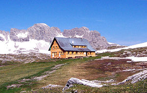
Goeppinger Hut
| Göppinger Hütte DAV hut category I |
||
|---|---|---|
| location | on the southeast edge of the Gamsboden; Vorarlberg , Austria | |
| Mountain range | Lechquellen Mountains | |
| Geographical location: | 47 ° 12 '53.2 " N , 10 ° 2' 45.3" E | |
| Altitude | 2245 m above sea level A. | |
|
|
||
| owner | Hohenstaufen Göppingen section of the DAV | |
| Construction type | hut | |
| Usual opening times | Mid June to early October | |
| accommodation | 23 beds, 41 camps , 10 emergency camps | |
| Winter room | 8 bearings | |
| Web link | Goeppinger Hut | |
| Hut directory | ÖAV DAV | |
The Göppinger Cabin is a 1913 built Alpenvereinshutte the section Hohenstaufen - Göppingen of the German Alpine Association in Lechquellengebirge , Vorarlberg , Austria .
location
The Göppinger Hütte is located at 2245 m on the southeast edge of the Gamsboden, northeast of the Johanneskopf. The hut is located in a karst area; the water supply is limited in dry summers. The delivery and disposal takes place via a 2.5 km long material ropeway, which was built a few years ago. Heavy loads have to be transported by helicopter.
Accesses
- from Lech (Vorarlberg) - Zug - Unteres Älple (to this point by car or bus), then approx. 2 hours ascent, southern slope
- from Sunday - Metzgertobel-Alpe, 3.5 hours ascent from the Alpe. The Biberach section points out that the former toll road to the Metzgertobelalpe is closed to general traffic and that you can only get to Buchboden by private car.
- from Schröcken (1269 m) to the Butzensee and over the Theodor-Prassler-Weg, or to the Fürkele (2145 m), over the Weimarer Steig and the Braunarlspitze and the Theodor-Prassler-Weg.
Neighboring huts and crossings
- to the Biberacher Hütte via the Alpschelle-Alpe and the Lite-Hütte, approx. 3 hours
- to the Freiburger Hütte via Steinmayerweg - Oberes Johannesjoch - Freiburger Weg, approx. 3½ to 4 hours, sure-footedness required
- To Oberlech via the promising Theodor-Prassler-Weg over the approx. 2400 m high Butzenschulter
summit
- Braunarlspitze ( 2649 m ): marked trail, first follow the Theodor-Prassler-Weg, then branch north to the summit ascent, 2½ hours, sure-footedness required
- Hochlichtspitze ( 2600 m ): path over scree and crags, a good 1 hour, sure-footedness required
- Eastern Johanneskopf ( 2508 m ): approx. 45 minutes
- West Johanneskopf (2573 m) 30 min. From eastern Johanneskopf
Trivia
Nearby is the macabre "Propeller Monument", a cast-in, bent propeller from an aircraft that was supposed to bomb the Messerschmitt works in Augsburg . However, the USAAF bomber crashed into the fog at the high-light peak.
literature
- Dieter Seibert: Area guide Bregenzerwaldgebirge and Lechquellengebirge. Bergverlag Rother , Munich 1989, ISBN 3-7633-3328-2 .
- Dieter Seibert : Bregenzerwald and Lechquellen Mountains. Alpine Club Guide alpine. 1st edition. Bergverlag Rother, Munich 2008, ISBN 978-3-7633-1095-1 .
Web links
Commons : Göppinger Hütte - collection of images, videos and audio files
Individual evidence
- ↑ Circular. No. 74, 2017, p. 8, editor: DAV section Biberach

