
Gösing (mountain)
| Goesing | ||
|---|---|---|
 Goesing from the south |
||
| height | 898 m above sea level A. | |
| location | Lower Austria , Austria | |
| Mountains | Gutenstein Alps | |
| Dominance | 3.7 km → Gahns | |
| Notch height | 224 m ↓ Kettenlüss | |
| Coordinates | 47 ° 44 ′ 19 ″ N , 15 ° 59 ′ 20 ″ E | |
|
||

The Gösing is 898 m above sea level. A. high mountain in the Gutenstein Alps and is located northwest of Ternitz at the entrance to the Sierningtal Nature Park in southern Lower Austria . To the north of the summit is the Neunkirchner Hütte, open all year round on weekends, owned by the Austrian Friends of Nature . To the northeast of the summit is the Flatzer wall .
Routes to the summit
There are two marked, easy climbs through the forest:
- from the east from Ternitz via Kindlwald to the summit (red marking, approx. 2 hours)
- from the north from Stixenstein, Flatz or Ternitz via the Neunkirchner Hütte and Kranzstetten to the summit.
caves
The following caves can be found on the south and west slopes of the Gösing:
- Warm gap 1861/22 (on the southern slope, location )
- Heisserloch 1861/19 (near Sieding)
- Pitch walls creeper
- Warm gap
- Hot hole
- Funny hole
- Sheephole
- Gösingkluft
- Heahnakräuln
- Step gap
- Bad luck cave
photos
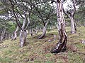
On the western slope, the wind blows the leaves and makes soil formation more difficult. Frugal black pines ( Pinus nigra subsp. Nigra ) grow on the poor soils .

View of the Sierning valley. The black pines on the rock show the typical "Paraplui" shape.

The Gösing Täschelkraut ( Noccaea goesingensis ) is a botanical rarity and was named after the mountain.

Carbonate rocks on the western slope with the Carpathian sparrow bush ( Spiraea media ), which is rare in Austria .

The rock spurge ( Euphorbia saxatilis ) occurs in the black pine forests on the Gösing and is endemic to the northeastern limestone Alps.

The Neunkirchner Naturfreundehaus above Flatz


Web links
Individual evidence
- ↑ Helga and Wilhelm Hartmann: Die Höhlen Niederösterreichs , Volume 1, 1979 and Volume 4, 1990 Research Center for Karst and Speleology: Journal for Karst and Speleology 1941, Pages 157-160