
Gücük
Coordinates: 36 ° 29 '11.4 " N , 34 ° 7' 57.5" E


Gücük is the Turkish name of an archaeological site in Rough Cilicia in southern Turkey. It consists of a Hellenistic tower and a farmstead built around it from a later period.
location
Gücük is located in the area of the former municipality of Kızkalesi in the Erdemli district of the Turkish province of Mersin , about three kilometers north of the center and 20 kilometers southwest of the district town. There, east of the Şeytan Deresi valley, the road from Kızkalesi, the ancient Korykos , leads northwest into the mountainous interior to Hüseyinler , Cambazlı and on to Uzuncaburç , the ancient Olba . You pass the remains of the settlements of Hıdırlı and Demirciören as well as the towers of Sarayın and Gömeç in the east and in the west the rock reliefs of Adamkayalar in the steep walls of the valley . Gücük is west of the road, about 500 meters southwest of the tower of Gömeç.
description
The main building and origin of the complex is the Hellenistic tower. It has an approximately square floor plan with a lower width of 5.10 meters and a preserved height of 5.33 meters. The interior is 3.66 × 3.87 meters. The door, which is slightly to the right, is located on the south side and measures between 0.69 and 0.85 meters in width and 1.42 meters in height. Like most of the numerous other towers in the Rough Cilicia between the rivers Kalykadnos in the west and Lamos in the east, on the territory of the Hellenistic priestly state of Olba, this one is also built using the Poygonal technique . On the southern entrance side, there are big differences in the dimensions of the stones between the corner stones and the middle ones. The corner stone in the fourth row on the right has dimensions of 0.50 × 1.36 meters, while its neighbor is only 0.24 × 0.50 meters. At 0.70 × 1.50 meters, the lintel exceeds all the stones on this front. On the other sides, the sizes are a bit more uniform. The thickness of the walls is between 0.73 and 0.78 meters. However, the upper layers have been supplemented recently. The large window on the west and the twin window on the east are also modern. As a result of these conversions, little can be said about the original design of the interior, only a gradation of the wall thickness in the floors is clearly visible.
Due to the wall technology and the stone processing, the Turkish archaeologist Serra Durugönül , who researched and measured the towers in Rough Cilicia together with her German colleague Hanns Gabelmann in 1995, comes to the conclusion that the building dates back to the time of the Olbian priestly dynasty, more precisely the early 2nd Century BC Is to be dated.
Several farm buildings belonging to a homestead can be seen in the vicinity of the tower. Directly in the west there is an arch to the tower, in the east at a distance of about 50 meters there is a pressing plant, in the south-east a cistern. According to Durugönül, these additions are of a later date.
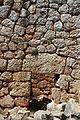
Entrance of the tower
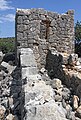
Tower from the west
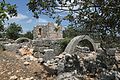
Gücük from the southwest

North and east sides from the inside with wall graduation


literature
- Serra Durugönül: towers and settlements in the Rough Cilicia. Asia Minor Studies Volume 28. Rudolf Habelt, Bonn 1998, ISBN 3-7749-2840-1 , pp. 24-27.
Web links
Individual evidence
- ↑ Serra Durugönül: Towers and Settlements in Rough Cilicia. Asia Minor Studies Volume 28. Rudolf Habelt, Bonn 1998, ISBN 3-7749-2840-1 , p. 1
- ↑ Serra Durugönül: Towers and Settlements in Rough Cilicia. Asia Minor Studies Volume 28. Rudolf Habelt, Bonn 1998, ISBN 3-7749-2840-1 , p. 123
- ↑ Hansgerd Hellenkemper , Friedrich Hild : New research in Kilikien. Publications of the commission for the Tabula Imperii Byzantini Volume 4. Verlag der Österreichischen Akademie der Wissenschaften, Vienna 1986, ISBN 3-7001-0771-4 , p. 67 sv km 3,9