
Hıdırlı

Coordinates: 36 ° 29 ′ 4 ″ N , 34 ° 8 ′ 40 ″ E

Hıdırlı in the hallway Demirciören is the Turkish name for the ruins of a settlement from the Roman Empire in Rough Cilicia in southern Turkey .
location
Hıdırlı is located about 2.5 kilometers north of Kızkalesi , the ancient Korykos , in the Erdemli district of the Mersin province . It is located east of the road that, past the rock reliefs of Adamkayalar and the towers of Gömeç and Gücük , leads east along the Şeytan Deresi valley via Hüseyinler to Cambazlı and on to Uzuncaburç , the ancient Olba . The road roughly follows the Roman connection from Korykos to Olba. A cobblestone path still visible in remnants connected the street with the settlement.
About 1.4 kilometers north of Hıdırlı is another parcel that is also called Demirciören. There are remains of a settlement , a church and the remains of a residential and watchtower from the 2nd century BC. Chr.
description
The place consisted of about 50 houses, of which at least one has a stone vault, the others have beamed ceilings, the support holes of which can still be seen. Some of them, which are built in polygonal construction , date from the imperial era, while others were partially extended with several storeys in the early Byzantine period. Most of the houses can be identified by the still standing door posts or frames. There were numerous underground cisterns for the water supply .
In the center of the village there is an early Byzantine church. It has the shape of a three-aisled basilica with a narthex to the west. The latter had three arched openings to the west and another entrance to the south. The interior was divided into three naves by two rows of five arcaded columns each . The north side facing the storms from the Taurus Mountains was windowless, the south wall had two double arched windows on the upper floor to the gallery . The apse also has two windows with a horseshoe-shaped arch, separated by a pillar. To the right and left of the apse there are pastophoria , to the southern one a multi-room, rectangular extension is attached.

Interior of a residential building with beam holes

Narthex of the church from the southwest
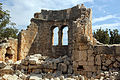
Apse of the church from the west

Church from the south with extension


Research history
The first explorers of the place were the archaeologist Josef Keil and the philologist Adolf Wilhelm in 1914 , who published a description and a floor plan of the church in their travel report. Christian archaeologist and art historian Otto Feld visited Hıdırlı before 1964. Hansgerd Hellenkemper and Friedrich Hild traveled to Cilicia in the 1980s and described the settlement.
literature
- Josef Keil , Adolf Wilhelm : Monuments from the rough Cilicia , (= MAMA 3), Manchester 1931, pp. 119–120 T. 45 Fig. 149
- Friedrich Hild, Hansgerd Hellenkemper: Kilikien and Isaurien. Tabula Imperii Byzantini Volume 5. Publishing house of the Austrian Academy of Sciences, Vienna 1990, ISBN 3-7001-1811-2 , p. 237 sv "Demirciören (1)"
- Hansgerd Hellenkemper, Friedrich Hild: New research in Kilikien. Publications of the commission for the Tabula Imperii Byzantini Volume 4. Verlag der Österreichischen Akademie der Wissenschaften, Vienna 1986, ISBN 3-7001-0771-4 , p. 67 sv "Km 3"
- Stephen Hill: The Early Byzantine Churches of Cilicia and Isauria . (= Birmingham Byzantine and Ottoman Monographs Volume 1), University of Birmingham 1996 ISBN 0860786072 pp. 144–147 fig. 24 pl. 55–58 sv "North of CORYCUS (Kızkalesi) (Demirciören)"
Web links
Individual evidence
- ↑ Serra Durugönül : Towers and Settlements in Rough Cilicia. Asia Minor Studies Volume 28. Rudolf Habelt, Bonn 1998 ISBN 3-7749-2840-1 p. 126
- ↑ In Hild / Hellenkemper: Cilicia and Isauria, Hıdırlı are called Demirciören (1) and the one to the north as Demirciören (2).