
Gürth (Bad Brambach)
|
Gurth
Bad Brambach municipality
Coordinates: 50 ° 14 ′ 49 ″ N , 12 ° 15 ′ 26 ″ E
|
||
|---|---|---|
| Residents : | 39 (2011) | |
| Incorporation : | July 1, 1950 | |
| Incorporated into: | Murmur | |
| Postal code : | 08648 | |
| Area code : | 037438 | |
Location of Gürth in Saxony |
||

Gürth is a district of the municipality of Bad Brambach in the Vogtlandkreis in Saxony .
Geographical location
The place is right on the north, west and south of the border with the Czech Republic . Gürth is 2 kilometers from the neighboring town of Raun . The connecting road runs over the Gürther Kreuz, an intersection of old transport links above the two villages.
history
The place belonged to the Voigtsberg office until the 19th century . On July 1, 1950, Gürth was incorporated into Raun and came to Bad Brambach on January 1, 1994 through the incorporation of Rauns.
Some farmsteads in the Egerland style have been preserved here. Valuable details of the former half-timbered building and historical courtyard entrances have been preserved with some examples.
Development of the population
|
|
|

Glance into the town on the street from Raun
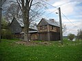
Farm with half-timbered house

Meadows in the valley of the Gürther Bach

Glance into a living room of a farmhouse


Web links
- Gürth in the Digital Historical Directory of Saxony
- Kur- und Tourismusverein eV: The Bad Brambacher districts . on www.badbrambach.de
Individual evidence
- ↑ a b Gürth. In: The Upper Vogtland (= values of our homeland . Volume 26). 1st edition. Akademie Verlag, Berlin 1976, p. 156.
- ↑ Historical place directory of Saxony
- ↑ Benno Kolbe: House and settlement and many things around it . Marienberg 2000, fig. 51, 53, 57, 59, 69, 70, 72, 92. ISBN 3-931770-27-3
- ↑ Cf. Gürth in the Digital Historical Directory of Saxony

Bad Brambach | Bear Village | Gürth | Hohendorf | Oberbrambach | Raun | Raunergrund | Rohrbach | Schoenberg am Kapellenberg