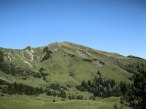
Galtjoch
| Galtjoch | ||
|---|---|---|
|
Galtjoch (south side) |
||
| height | 2109 m above sea level A. | |
| location | Tyrol , Austria | |
| Mountains | Lechtal Alps ( Liegfeist group ) | |
| Dominance | 1 km → Steinkarspitze | |
| Notch height | 120 m ↓ Scharte to the Steinkarspitze | |
| Coordinates | 47 ° 23 '40 " N , 10 ° 40' 33" E | |
|
|
||
| Normal way | Rinnen - Raazalpe - Galtjoch | |
The Galtjoch is 2109 m above sea level. A. high mountain in the Lechtal Alps in the Austrian state of Tyrol .
location
The Galtjoch lies within the Lechtal Alps in the Liegfeist group . To the southwest, the Galtjoch is connected to the Knittelkarspitze by a mountain ridge about two kilometers long . The Rainberg in the north and the Abendspitze in the east are two upstream peaks. The most important valley locations at the foot of the mountain are Kelmen in the south and Rinnen near Berwang in the east.
Paths to the summit
The summit is easy to reach from Rinnen via forest paths and simple, marked hiking trails and leads past the managed Ehenbichler Alm (1694 m). From the west, the summit can be climbed via the Reuttener Höhenweg . In winter it is a popular destination for ski and snowshoe tours , as the ascent is easy and has little danger of avalanches.
Literature and map
- Dieter Seibert: Alpine Club Guide alpine - Lechtal Alps . 2nd Edition. Bergverlag Rother , Munich 2008, ISBN 978-3-7633-1268-9
Individual evidence
- ^ Federal Office for Metrology and Surveying Austria: Austrian Map online (Austrian map 1: 50,000) . Retrieved September 23, 2012.
- ↑ Compass map no. 4 Füssen-Ausserfern , Kompass-Karten GmbH, Rum / Innsbruck Austria
- ↑ Markus Stadler: Munich ski touring mountains: 80 fantastic ski touring destinations , Bergverlag Rother GmbH, Munich, 1st edition 2012, ISBN 978-3-7633-3065-2 , from page 32

