Gamalama
| Gamalama | ||
|---|---|---|
|
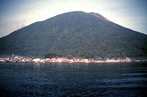
The Gamalama by Sea (January 1980) |
||
| height | 1715 m (varies) | |
| location | Ternate in front of Halmahera , ( Indonesia ) | |
| Coordinates | 0 ° 48 ′ 0 ″ N , 127 ° 20 ′ 0 ″ E | |
|
|
||
| Type | Stratovolcano | |
| Last eruption | December 18, 2014 | |
|
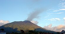
Eruption around 1720 |
||
The Gamalama volcano on the volcanic island of Ternate is one of the most active volcanoes in Indonesia . It is located in the Maluku Utara province in the Moluccas in eastern Indonesia. The Gamalama is part of a volcanic chain that has formed west of the island of Halmahera , including the Gamkonora on the island of Tidore , the Hiri or the Makian .
Overview
The Gamalama has three craters that become younger towards the north. The eruptions are mostly explosive from the summit craters; but there were also flank eruptions and pyroclastic currents . According to the 2010 census, the approximately 110 square kilometer island of Ternate had about 176,000 inhabitants, of which about 161,300 lived in the east in the city of Ternate and its outskirts.
history
In 1513 the Portuguese were the first Europeans to reach Ternate. In 1605 it was conquered by the Dutch . The island was an important center of the spice trade , which is why there are numerous descriptions of eruptions of the Gamalama. Around 60 outbreaks are known for the period from 1510 to 2008.
Around 1,300 people died in an eruption in 1775, some of them from pyroclastic surges that accompanied the formation of a maar in the north of the island. The Tolire Besar , a lake with a diameter of around 600 meters and a maximum depth of over 40 meters , formed in the maar . With the Tolire Kecil not far from the Tolire Besar and the Ngade in the south of the island, there are two other maars on Ternate, in which there are lakes. The volcanic eruption in February 1840 was accompanied by an earthquake that destroyed or seriously damaged numerous buildings on the island.
In September 1980 around 40,000 of the then around 60,000 islanders fled to the neighboring island of Tidore after the Gamalama emitted glowing tephra and thus triggered forest fires. Around four inches of ash fell in the city of Ternate . The eruptions ended in October 1980. The residents returned; some villages in the northeast of the island remained evacuated.
On December 9, 2011, a four-kilometer-high ash cloud rose over the Gamalama. Volcanic tremors and an increasing number of earthquakes had been recorded prior to the eruption , so a higher alert was declared on December 4th. On December 27th, heavy rains mobilized ash deposits that flowed down two valleys in the form of streams of mud called cold lahars . Four people were killed and dozen injured; numerous houses were destroyed. In the following months, most recently in October 2012, there were further eruptions.
In an eruption on December 18, 2014, ash and rocks were thrown up about 2000 meters. Several mountaineers were injured while trying to escape, one was missing.
In early October 2018, ash was ejected in a small eruption. A restricted zone with a radius of 1.5 km was set up around the crater.
Web links
- Gamalama in the Global Volcanism Program of the Smithsonian Institution (English)
- Gamalama near Oregonstate (English)
- photos
Individual evidence
- ↑ Hasil Sensus Penduduk 2010. Kota Ternate. Data aggregate per Kecamatan. (Indonesian, pdf, 2.8 MB, accessed February 13, 2013).
- ↑ a b c Gamalama . On: volcano.si.edu
- ↑ Gamalama in The Significant Volcanic Eruption Database of NOAA (accessed February 17, 2013).
- ↑ Fajar Setiawan, Hendro Wibowo, Budi Santoso Arianto, Order a copy Nomosatryo, Ivana Yuniarti: Kondisi Limnologi Danau Tolire, Pulau Ternate. In: Prosiding Seminar Nasional Limnologi VI Tahun 2012 , pp. 535–547, here pp. 535f. (English / Indonesian, download ( Memento of the original from March 24, 2017 in the Internet Archive ) Info: The archive link has been inserted automatically and has not yet been checked. Please check the original and archive link according to the instructions and then remove this note. , PDF, 540 kB )
- ^ Entry in NOAA's The Significant Earthquake Database (accessed February 17, 2013).
- ↑ http://orf.at/#/stories/2258335/ Injured people in volcanic eruption in Indonesia, ORF.at, December 19, 2014
- ↑ Gamalama volcano (Ternate Island, Indonesia): continuing ash emissions, airport closed until 11 am Saturday. In: volcanodiscovery.com. October 5, 2018, accessed October 7, 2018 .


