Gamskögel
| Gamskögel
Gamskogel ridge
|
|
|---|---|
|
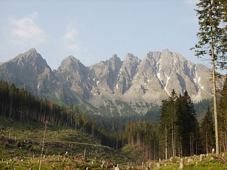
View of the four Gamskögel, from the north from the rear Triebental , to the left the Mödringkogel |
|
| Highest peak | (Western) Gamskogel ( 2386 m above sea level ) |
| location | Styria , Austria |
| part of | Seckauer Tauern , Lower Tauern |
| Coordinates | 47 ° 21 '57 " N , 14 ° 32' 54" E |
| rock | Granite and gneiss granite |
The Gamskögel form with 2386 m above sea level. A. the highest elevation of the Triebener Tauern , a subgroup of the Seckauer Tauern in the Lower Tauern .
Location and landscape
The Gamskögel are the imposing end of the Triebental valley east of Hohentauern .
The summit group includes the Eastern Gamskogel (approx. 2180 m ), two peaks called the Middle Gamskogel (approx . 2240 m and 2320 m ), and the main peak, the West Gamskogel . In a broader sense, the Mödringkogel ( 2142 m above sea level ) east and Hochleitenspitze ( 2329 m above sea level ) west of the group, also known as the Gamskogelgrat or Gamskögelgrat .
The Queen rock stands in front of the Mödringalm . The Kartäler south is called Bärentritt and Hühnersteige , here are some small carlacks .
To the north, the Triebenbach (with its source brook Mödringbach ) flows to the Palten , and this to the Enns . The Bärntalbach , a tributary of the Pöls, rises to the west . To the south is the headwaters of the Gaalbach with Musenbach and Krugsee , which goes to Ingeringbach . The latter two main rivers flow into the Mur . This means that the peaks belong to the main Alpine ridge .
The main ridge of the Seckau Alps leads eastwards via Krugtörl (approx. 2150 m ) and Speikleitenberg ( 2124 m above sea level ) to the massif of the Kettentalkogel ( 2152 m above sea level ) and on to the Geierhaupt or south-east the ridge to Pletzen . The main ridge leads northwards over the Mödringer Törl (approx. 2090 m ) and the Knaudachkogel ( 2227 m above sea level ) to the Grießstein massif (Great 2337 m above sea level ), and on to the Triebener Tauern Pass . South branches on Gaaler Törl ( 2,061 m ) on the Hochleiten top a ridge to the south, the over Amachkogel ( 2311 m above sea level. A. ) and Kesseleck ( 2308 m above sea level. A. ) to Gaaler ridge leads the Pölstal and Seckauer pool separates .
Routes
Possible increases are:
- Not difficult from the north via the Mödringalm , walking time from the Triebental about 3 hours
- from the east as a ridge crossing over the eastern and middle Gamskogel to the highest elevation, the western Gamskogel ( II , with places III), and often climbed.
literature
- Günther and Luise Auferbauer: Bergtourenparadies Steiermark , Styria, Graz 2000, ISBN 978-3-222-12783-0 , S. oA
Individual evidence
- ↑ a b Gamskögel 2386m, Gamskögelgrat. styria-alpin.at - Tour description.
