
Triebental
| Triebental | ||
|---|---|---|
| location | Styria | |
| Waters | Triebenbach | |
| Mountains | Wölzer Tauern , Niedere Tauern | |
| Geographical location | 47 ° 26 ' N , 14 ° 32' E | |
|
||
| height | 1100 m | |
| length | 14 km | |

The Triebental is a valley in Upper Styria . It also forms a village in the municipality of Hohentauern in the Murtal district .
geography
|
Triebental locality |
|
|---|---|
| Basic data | |
| Pole. District , state | Murtal (MT), Styria |
| Judicial district | Judenburg |
| Pole. local community | Hohentauern ( KG Hohentauern) |
| Coordinates | 47 ° 25 '40 " N , 14 ° 32' 14" E |
| Residents of the village | 79 (January 1, 2020) |
| Building status | 47 (addr. 2019 ) |
| Statistical identification | |
| Locality code | 15270 |
| Counting district / district | Hohentauern (62010 000) |
| Local documents Vordertriebental and Hintertriebental Source: STAT : Gazetteer ; BEV : GEONAM ; GIS-Stmk |
|
The Triebental is a left side valley of the Paltental . It stretches for about 12 kilometers from Trieben southeast into the Seckauer Tauern . The Paltental belongs to the Liezen district , the Hohentauener municipal area ( Murtal district ) is still north of the Enns – Mur watershed on the shoulder height . The area is located 25 kilometers north of Judenburg , east below the municipality's capital Hohentauern .
The valley is traversed by the Triebenbach . It starts right by the town of Trieben , and is initially a narrow gorge, the Wolfsgraben , which still falls partly into the Triebener municipality. This is where the Sunkbach , which drains the Hohentauen area, joins the Sunk gorge .
Only after a few kilometers does it expand into the scattered settlement Vordertriebental . At the beginning of the village, the B114 Triebener Straße leaves the valley and heads southwest up the Tauernbach to Hohentauern on the Triebener Tauernpass , and over into the Pölstal . Far back in the valley are the Hintertriebental houses , which stretch almost to the end of the valley.
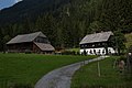
This town of Triebental , with around 50 addresses and around 80 inhabitants (January 1st, 2020: 79), covers the entire settlement of the valley.
At the head of the valley there is a wide basin between Grießstein , Gamskögeln and the pre- peaks of the Geierhaupt . Here the Knaudachtörl and the less accessible Mödringer Törl lead over into the Pölstal, the Krugtörl into the valley of the Gaalbach , and the Kettentörl to the Ingeringbach .
|
|
(both Gem. Gaishorn a.See ) ∗
|
|
| Hohentauern |
.svg)
|
|
| Sankt Johann am Tauern Sonnseite (Gem. Pölstal ) ∗ |
Gaalgraben (Gem. Gaal ) ∗ |
|
- ∗ Behind the mountain ranges

Forsthaus Triebental (listed)
Königsbachhube (Wolfgerhube , listed)

Panorama in the Hintertal: Gamskögel


literature
- Anniversary booklet for the 50th anniversary of the Triebentalhütte. = Announcements of the Academic Section Graz of the Austrian Alpine Club 25 (Oct. 1978) - various contributions to the Triebental.
Individual evidence
- 62010 - Hohentauern. Community data, Statistics Austria .

Cadastral municipality: Hohentauern
Locations: Hohentauern | Triebental
Village:
Hohentauern |
Settlements:
mining •
Moscher holiday complex |
Scattered Houses:
Hintertriebental •
Hohentauern-Scattered Houses •
Vordertriebental |
Other locations:
Edelrautehütte •
Hammer •
Königsbachhube •
Triebental (forester's house) •
Triebentalhütte
Almen:
Scheibelalm
Counting district: Hohentauern
Former community name: Hohenthauern