Chamois lace
| Large chamois tip | ||
|---|---|---|
|
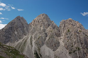
Kleine and Große Chamswiesenspitze and Bloßkofel (from left to right) |
||
| height | 2486 m above sea level A. | |
| location | Tyrol , Austria | |
| Mountains | Lienz Dolomites , Gailtal Alps | |
| Dominance | 1 km → Simonskopf | |
| Notch height | 201 m ↓ Kerschbaumertörl | |
| Coordinates | 46 ° 45 '59 " N , 12 ° 46' 59" E | |
|
|
||
| First ascent | 1893 by Peter Paul Steidl, led by Mathias Marcher (tourist) | |
| Normal way | From the southwest over the Kerschbaumeralm through a steep cirque, then over the summit meadow | |
The Gamswiesenspitzen form a 2486 m above sea level. A. high mountain range in the central part of the Lienz Dolomites . The Kleine Gamswiesenspitze is immediately in front of the main summit Große Gamswiesenspitze to the south, while the Bloßkofel ( 2400 m ) connects to the north . The mountain range of the Gamswiesenspitzen borders the Laserz, an impressive mountain basin, to the west.
Tourist development
The normal route branches off at around 2160 m from the path between Kerschbaumertörl and Kerschbaumeralm and then winds through a very steep, partly rugged and rockfall-prone cirque to around 80 m below the summit into the gap between the two main peaks. The rest of the way leads over the relatively steep but easy to climb grassy ridge of the Großer Gamswiesenspitze ("Chamswiese"). In 1893 , Peter Paul Steidl and the Lienz mountain guide Mathias Marcher were the first tourist to reach the summit on this route - then a hunting trail .
In 2006, a via ferrata was built, which branches off the normal route in the lower part and has some exciting individual points such as a rope bridge, a small Scharterl and some exposed points in the summit structure (difficulty level C). The Madonna, which gives the path its name, is also an interesting sight with its disco ball halo. After reaching the summit of the Großer Gamswiesenspitze, follow the normal route into the notch in front of the Kleiner Gamswiesenspitze, in the north flank of which the path continues and leads to it over beautiful slabs and a pretty summit ridge. The descent into the Kerschbaumertörl is another ascent variant and offers Schrofen terrain and a few easy insured spots (AB).
There are various medium-difficulty alpine climbing routes, especially on the west side, for example the Gamsplatten ( UIAA V-, 10 pitches) or the northeast edge (UIAA IV, 10 pitches).
Literature and map
- Kompass hiking, biking and ski touring map sheet 47, 1: 50,000, Lienz Dolomites, Lesachtal Carnic High Trail
- Csaba Szépfalusi: All via ferratas in Tyrol . Tyrolia-Verlag, Innsbruck-Vienna. ISBN 978-3-7022-2816-3
- Hubert Peterka, Willi End: Alpine Club Guide Lienz Dolomites . Bergverlag Rudolf Rother Munich 1984, ISBN 3-7633-1243-9
Individual evidence
- ^ Journal of the German and Austrian Alpine Club , Volume 30, 1899, p. 302


