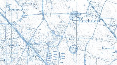
Guardsman (desert)
Gardist , also Gartsin or Garchen , is the name of an abandoned Niederungsburg in the Principality of Rügen . It is an archaeological and documented desertification south of Kirchdorf in the municipality of Sundhagen in the district of Vorpommern-Rügen , Mecklenburg-Western Pomerania .
geography
Guard is located around 1200 m south of Kirchdorf and 1600 m west of Kowall in a lowland, between the Angermünde – Stralsund railway line and the B 105 (formerly B 96) from Greifswald to Stralsund .
There is a double-developed, young Slavic castle wall , with the field name "The Castle", more than 200 m long and around 90 m wide on what is now a wooded elevation.
history
In 1207 Jaromar I notarized the possession of land to the Eldena monastery "in castro Garchen" . In the documents Jaromars I of 1209, Barnutas of 1221 and the Duke Wartislaw III. From 1241 and 1248, a guardsman was named in the border description for the confirmation of the goods and lands assigned to the Eldena Monastery. In 1241 Wizlaw I confirmed his brother Barnuta's will in the Guard. In the document of Dobislaw von Gristow from 1249 only one mountain called Gardyst was mentioned. The castle was probably abandoned soon after Barnuta's death.
Another mention is possible with Castrum Ghart from 1275, Th. Pyl equates this with the guardsman , because there is no evidence of a castle rampart in the lordship of Gristow including the island of Koos, which plays a role here. The iron finds from the castle wall confirm its continued use in early German times, even if it was no longer used as the seat of the von Gristow family.
The Wendish place name is interpreted as "fortress with stone wall".
The weir system with the field name "Die Burg" has been a ground monument with the site no. Kirchdorf 1 under protection. However, it was already listed in Otto Kunkel's castle wall directory in 1932 as "Kirchdorf - Grenzbeschreibung Gardist". This can be seen as protection for the time.
Archaeological finds from the castle ramparts were:
- Ceramics: Young Slavic sherds, Vipperower Group
- Iron parts: 2 lance tips, 1 arrowhead, 1 ax, 1 wheel spur , fragment of another spur
Individual evidence
- ^ Almut Spangenberg: The low moor area near Mesekenhagen with the area natural monuments Heidehügel and inland salt station. In: Landscape ecological excursions in the Greifswald area. (= Greifswald Geographical Works. Vol. 30), Ernst-Moritz-Arndt University Greifswald 2003, p. 30.
- ^ Pomeranian document book . PUB I, No. 145.
- ^ Pomeranian document book . PUB I, No. 148.
- ^ Pomeranian document book . PUB I, No. 207.
- ^ Pomeranian document book . PUB I, No. 392.
- ^ Pomeranian document book . PUB I, No. 478.
- ^ Pomeranian document book . PUB I, No. 501.
- ^ Gunnar Möller: History and Settlement of the Terra Gristow from the 7th to 14th century. In: Haik Thomas Porada (ed.): Contributions to the history of Western Pomerania. The Demminer Colloquia 1985–1994. Thomas Helms Verlag, Schwerin 1997, ISBN 3-931185-11-7 , pp. 319-321.
- ^ Pomeranian document book . PUB II, No. 1017.
- ^ A b Manfred Niemeyer: Ostvorpommern . Collection of sources and literature on place names. Vol. 2: Mainland. (= Greifswald contributions to toponymy. Vol. 2), Ernst-Moritz-Arndt University of Greifswald, Institute for Slavic Studies, Greifswald 2001, ISBN 3-86006-149-6 . P. 36
- ↑ List of surface monuments in Mecklenburg-Western Pomerania, Schwerin 2003, serial no.143
Coordinates: 54 ° 9 ′ 48.4 ″ N , 13 ° 16 ′ 53.7 ″ E
