
Georgenberg (Vienna)
| Georgenberg | ||
|---|---|---|
 South slope of the Georgenberg |
||
| height | 328 m above sea level A. | |
| location | Vienna , Austria | |
| Mountains | Vienna Woods | |
| Coordinates | 48 ° 8 '48 " N , 16 ° 15' 10" E | |
|
||

The Georgenberg , also Sankt-Georgen-Berg , is 328 m above sea level. A. hoch Berg in the 23rd district of Liesing , on the southern outskirts of Vienna .
The architecturally unusual Wotruba Church and the star garden of the Austrian Astro Association are located in the popular recreation area .
geography
Georgenberg is located in the Mauer part of the district at the transition from the built-up area to the Vienna Woods . In the west the Antonshöhe and the Wilde Berg adjoin the forest , in the east it merges into the Sauberg . The northern slope of the Georgenberg, which slopes down towards Maurer Langen Gasse and is built on with residential buildings, bears the field name Schafleiten .
The Georgenberg contributes to the geological stage of the Sarmatian in the north and east , in the south in the Badenium and in the west in the Frankenfels blanket of the Northern Limestone Alps .
history
In 1938 the air news troop barracks were built on the Georgenberg , which was demolished in 1949, leaving a ruined area where the armed forces held exercises. 1974–1976 the Wotrubakirche was built , a building made of concrete blocks based on designs by the sculptor Fritz Wotruba . The Sterngarten , an open-air planetarium, has been located on the Georgenberg since 1997 .
The through traffic to Kalksburg on the Kalksburger Strasse crossing the Georgenberg has been prevented for a long time by blocking the road to car traffic southwest of Anton-Krieger-Gasse; the entrance to the Wotruba Church, on the other hand, has been developed in such a way that it can also be mastered by tourist buses. The street in front of the church was named after its initiator, Margarethe Ottilinger , Ottillingerplatz (alternative spelling) in 2012 .
- gallery
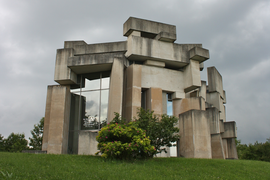
Wotruba Church

Star garden

Pine stand


Individual evidence
- ↑ Map of Wall in: Chronicle of the Wall School 3. Part 1 , ed. v. Maurer Heimatrunde - Association for local history, local history and home care. Self-published, Vienna 2006. P. 76 f.
- ^ Friedrich Brix: Brief geological considerations on the 23rd district of Vienna, Liesing . In: Ferdinand Opll: Liesing: History of the 23rd Viennese district and its old places . Jugend und Volk, Vienna 1982, ISBN 3-7141-6217-8 . P. 230