Sauberg (Liesing)
| Sauberg | ||
|---|---|---|
|
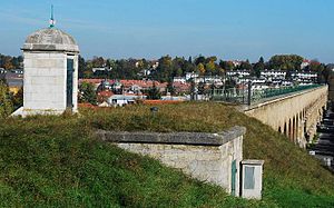
View over the Liesingtal to the Sauberg |
||
| height | 259 m above sea level A. | |
| location | Vienna , Austria | |
| Mountains | Vienna Woods | |
| Coordinates | 48 ° 8 '38 " N , 16 ° 16' 36" E | |
|
|
||
The Sauberg is a 259 m high mountain in the 23rd Viennese district of Liesing .
geography
The Sauberg is the southernmost of a chain of hills in the Eastern part of the district wall through which the at Rose Hill ending I. Vienna Spring water pipe runs and the geological stage of Sarmatiums is counted. In the north, the valley between Sauberg and Steinberg, through which the Knotzenbach previously flowed, is bridged by the Mauer aqueduct , and in the south the valley over the Liesingbach is bridged by the Liesing aqueduct .
The southern slope of the Sauberg, which is separated from it by a small valley along Anton-Krieger-Gasse and a flat saddle (at Johann-Teufel-Gasse 54–56), belongs to the district of Liesing and bears the name Hadersbergen . An old field name around the summit is Haiden (this is what today 's Zeidlergasse was named after until 1957), while in the Franziszeischen cadastre the Sauberg hall is still located in the area between today's Schwarzwaldgasse and Anton-Krieger-Gasse. In the west, the Sauberg crosses the Brennen and Liebeggen corridors into the Georgenberg, which is around 60 m higher .
Important structures
The Sauberg is characterized by a loose structure with villas and residential complexes. In addition to the aqueducts already mentioned, the Anton-Krieger-Gasse school center is a striking building on the Sauberg. It was built in 1974 according to plans by the architect Ferdinand Riedl . In the southeast of the Sauberg is the Art Deco building of the Johanneskirche and in the valley floor of the Steinberg is the neo-Gothic Church of the Redeemer . Villas from the interwar period have been preserved in particular in Anton-Krieger-Gasse. Among their architects are Hans Hornek, Leopold Schumm , Anton Waldhauser and Julius Zagler.
Individual evidence
- ↑ Ferdinand Opll: Liesing: History of the 23rd Viennese district and its old places . Jugend und Volk, Vienna 1982, ISBN 3-7141-6217-8 , p. 230.
- ^ Habsburg Monarchy - Franziszeischer Cadastre (here: 1817-1819) | Mapire - Historical Maps of the Habsburg Empire. In: mapire.eu. Retrieved February 18, 2020 .
- ^ Map of the municipality of Mauer near Vienna . In: Heinz Böhm (Ed.): Chronicle of the school wall . Volume 3. Maurer Heimatrunde, Vienna 2006, pp. 76-77.
- ^ Dehio-Handbuch Wien. X. to XIX. and XXI. to XXIII. District . Edited by Federal Monuments Office. Anton Schroll, Vienna 1996, ISBN 3-7031-0693-X , pp. 706-707.

