Ghanzi
| Ghanzi | ||
|---|---|---|
|
|
||
| Coordinates | 21 ° 42 ′ S , 21 ° 39 ′ E | |
| Basic data | ||
| Country | Botswana | |
| Ghanzi District | ||
| ISO 3166-2 | BW-GH | |
| height | 1145 m | |
| Residents | 14,809 (2011) | |
| founding | around 1870 | |
|
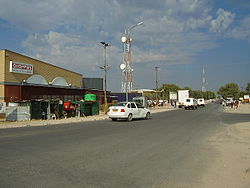
Main street in Ghanzi
|
||
Ghanzi (sometimes Ghantsi ) is a city in the Ghanzi District in Botswana . It is the administrative seat and the largest town in the district.
geography
In 2011 Ghanzi had 14,809 inhabitants. Around a third of the population of the 117,910 square kilometer district lived in the city.
Ghanzi is located in the Kalahari and is also called "the capital of the Kalahari". The environment is flat sandveld . It is around 70 kilometers to the Namibian border.
Basarwa and Bakgalagadi, who belong to the San , as well as Baherero live in the city .
Climate table
|
Average monthly temperatures and rainfall for Ghanzi
Source: wetterkontor.de
|
|||||||||||||||||||||||||||||||||||||||||||||||||||||||||||||||||||||||||||||||||||||||||||||||||||||||||||||||||||||||||||||||||||||||||||||||||||||||||||||||||||||
history
For a long time there were only San residents in the area. In 1874, Hendrik van Zyl, the first Boer who belonged to the Dorsland trekkers , settled there . Especially at the end of the 1890s, more Boers reached the place they called Kamp .
Economy and Infrastructure
The population lives mainly from cattle breeding.
The Ghanzi Airport ( IATA code GNZ, ICAO code FBGZ ) lies directly on the eastern edge of the city and is operated in the charter and private traffic. Road connections exist with the A2 west to Namibia and south-east to Lobatse and with the A3 east to Maun and Francistown . Both highways are part of the Trans-Kalahari Highway .
The local hospital is called Ghanzi Primary Hospital.
See also
Individual evidence
- ↑ 2011 Census Report, PDF page 170. ( Memento from June 2, 2015 in the Internet Archive ) (English; PDF; 4.35 MB)
- ↑ a b Ghanzi at botswana-travel.org (English), accessed on June 5, 2015
- ↑ Entry at medpages.co.za (English), accessed on June 5, 2015


