
Ghanzi District
| Ghanzi | |
|---|---|
  |
|
| Basic data | |
| Country | Botswana |
| Capital | Ghanzi |
| surface | 117,910 km² |
| Residents | 43,355 (2011) |
| density | 0.4 inhabitants per km² |
| ISO 3166-2 | BW-GH |
Coordinates: 21 ° 42 ′ S , 21 ° 39 ′ E
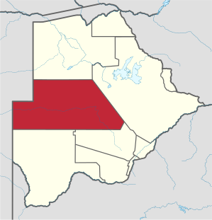
Ghanzi (sometimes written Ghantsi ) is a district in Botswana . It is 117,910 km² and has 43,355 inhabitants (according to the 2011 census).
The district is located in the west of the country, borders with Namibia and also includes a large part of the interior. The eastern half consists largely of the Central Kalahari Game Reserve . The seat of the administration is in Ghanzi .
The Ghanzi- Chobe Fold Belt is an approximately 140 kilometers wide belt of metavolcanic rock in the west and north of Botswana, which belongs to the Kalahari Copper Belt .
Climate table
|
Average monthly temperatures and rainfall for Ghanzi
Source: wetterkontor.de
|
|||||||||||||||||||||||||||||||||||||||||||||||||||||||||||||||||||||||||||||||||||||||||||||||||||||||||||||||||||||||||||||||||||||||||||||||||||||||||||||||||||||
Individual evidence
- ↑ 2011 census, including residents of the Central Kalahari Game Reserve (PDF), accessed December 14, 2014
- ↑ Geological description at portergeo.com.au (English), accessed on June 5, 2015
Districts: Central |
Chobe |
Ghanzi |
Kgalagadi |
Kgatleng |
Kweneng |
North East |
North West |
South East |
Southern
Self-Governing Cities: Francistown |
Gaborone |
Jwaneng |
Lobatse |
Selebi-Phikwe |
Sowa