
Chobe District
| Chobe District | |
|---|---|
  |
|
| Basic data | |
| Country | Botswana |
| Capital | Kasane |
| Residents | 23,347 (2011 census) |
| ISO 3166-2 | BW-CH |
Coordinates: 18 ° 21 ′ S , 24 ° 42 ′ E
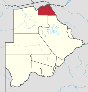
The Chobe District is a district of Botswana . With 23,347 inhabitants, it is the country's poorest district in terms of population.
Until 2006, the district formed the east of the North West District . It was previously independent but was merged with the Ngamiland District .
The district borders clockwise, starting in the north, with the Caprivi Strip in Namibia , Zimbabwe , the Central District , the Kgalagadi District and the North West District. A large part of the district is protected as Chobe National Park . The district is named after the Chobe River. The administrative seat of Kasane is located on the Chobe and has around 9,000 inhabitants. Kazungula , Botswana's only town on the Zambezi , is the second largest town in the district.
Individual evidence
- ↑ District Councils at gov.bw (English), accessed on December 14, 2014
- ↑ 2011 census (English, PDF), accessed on December 14, 2014
- ^ Message at iso.org ( Memento of December 18, 2008 in the Internet Archive ) (English, PDF), accessed on December 14, 2014
Districts: Central |
Chobe |
Ghanzi |
Kgalagadi |
Kgatleng |
Kweneng |
North East |
North West |
South East |
Southern
Self-Governing Cities: Francistown |
Gaborone |
Jwaneng |
Lobatse |
Selebi-Phikwe |
Sowa