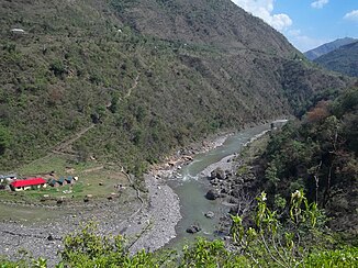
Giri (Yamuna)
| Giri | ||
|
Giri in the middle section of the river |
||
| Data | ||
| location | Himachal Pradesh ( India ) | |
| River system | Ganges | |
| Drain over | Yamuna → Ganges → Indian Ocean | |
| source |
Front Himalayas 31 ° 4 ′ 26 ″ N , 77 ° 38 ′ 55 ″ E |
|
| Source height | approx. 3000 m | |
| muzzle |
Yamuna Coordinates: 30 ° 26 ′ 51 " N , 77 ° 40 ′ 12" E 30 ° 26 ′ 51 " N , 77 ° 40 ′ 12" E |
|
| Mouth height | approx. 400 m | |
| Height difference | approx. 2600 m | |
| Bottom slope | approx. 19 ‰ | |
| length | approx. 140 km | |
The Giri (also Giriganga ; Hindi गिरि गंगा Giri Gaṅgā ) is a right tributary of the Yamuna in the Indian state of Himachal Pradesh .
The Giri rises in the Front Himalayas in the Shimla district . It initially flows about 30 km in a westerly direction and then turns to the southwest. The Giri now forms the border between the districts of Solan and Sirmaur . After another 30 km, the river turns to the southeast and later to the east, dividing the Sirmaur district into two parts of equal area. In the south, a ridge of the Siwalik range separates the river valley from the Ganges plain . After 140 km the Giri reaches the right bank of the Yamuna, which is just leaving the mountains. About 40 km above the mouth, part of the river water is fed through a tunnel to a 7 km south-southeast located hydropower plant on the southern slope of the mountain ridge to the south. The Girinagar hydropower plant has two turbines of 30 MW each. Below the hydroelectric power station, the water flows towards the river Bata .
