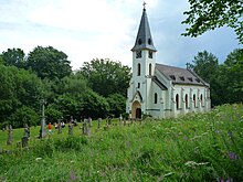
Zvonková
Zvonková (German Glöckelberg ) is a desert in the Bohemian Forest in the Czech Republic . It belongs to the town of Horní Planá ( Oberplan ) in Okres Český Krumlov and forms a cadastral district with an area of 3920.4592 hectares.
geography
Zvonková is located six kilometers southwest of Horní Planá between the Lipno reservoir and the border with Austria at the western foot of the Zvonkovský vrch ( Wuselberg , 845 m) in the Šumava National Park and Protected Landscape Area in South Bohemia .
To the north are the Josefův Důl (also spelled Josefodol) and Huťský Dvůr (former places Josefsthal and Hüttenhof of the municipality of Glöckelberg), to the northeast Přední Zvonková (Vorder Glöckelberg), and to the southeast are the Račín (Ratschin) and Pestřice (Stögenwald) desert areas. Already on the Austrian side are Sonnenwald to the south, Schöneben to the southwest ( Ulrichsberg municipality ), Pfaffetschlag and Pfaffetschlaghäuseln to the west, and Rehberg and Holzschlag to the northwest ( Klaffer am Hochficht municipality ).
history
The village was founded around 1670. A chapel was built in 1785 and a church began to be built in 1788. When the church was founded, a school was also established. The church burned down in 1876 and the new Gothic church was built on the site. After 1918 the village was added to the newly created state of Czechoslovakia . In the course of the Munich Agreement , the Sudetenland became part of the German Reich in 1938 . In 1939 it was assigned to the district of Krummau an der Moldau in the Reichsgau Oberdonau . In 1945 Glöckelberg came back to Czechoslovakia and most of the residents were expelled . After the beginning of the Cold War , the residents were forcibly evacuated because of the close proximity to the border and the village was razed down to the church.
Josefsthal glass factory
The glass factory in Josephsthal was in operation from 1823 until the chimney was blown up in 1930. The often fluctuating glassmakers migrated from the glassworks in the Gratzener Bergland , in the Waldviertel and in Seewiesen or came from the surrounding parishes of Schwarzenberg am Böhmerwald , Ulrichsberg or Aigen, from the Hausruckviertel , from Bavaria, Northern Bohemia, Hungary and from Polish Galicia . Many glass workers at the Sonnenwald rival hut, which has existed since 1749, are recorded in both the Aigner and Glöckelberg registers, whereby the Sonnenwald population has a pronounced social and parish orientation towards Glöckelberg and the Vltava valley. The Huťský Potok ("Hüttenbach") still reminds of the glassworks.
Attractions
- Church of St. John Nepomuk
- Natural monuments Házlův kříž (66 ha), Prameniště Hamerského potoka u Zvonkové ( headwaters of the Hammerbach, 55 ha) and Úval Zvonková (Glöckelberg valley, now part of the Šumava National Park )
Personalities
- Engelmar Unzeit , pastor in Glöckelberg from 1940, was beatified in 2016 as a confessor and martyr during the National Socialist era .
literature
- Franz Petschl (Ed.): Glöckelberg. History of a Bohemian Forest community. Ludwig Stark Verlag, Oberstenfeld 1992, 468 pages, ISBN 9783925617164 .
- Alois Eßl (Alois Essl): History of the development of the community Glöckelberg, then its further settlement and increase and more other incidents. Budweis 1899, 117 pages.
Web links
- History, reconstructed maps and pictures of Glöckelberg on gloeckelberg.at.
- Franz Haudum: Glöckelberg parish archive. Official notices 1787-1938. Wilhering 2009, 79 pages.
Individual evidence
- ↑ http://www.uir.cz/katastralni-uzemi/643734/Zvonkova
- ^ Glöckelberg (Zvonková) - exhibition at the place of history . In: Online encyclopedia encyklopedie.ckrumlov.cz about Krummau .
- ↑ Haudum 2009, p. 3.
- ^ Letter from the Glöckelberg parish to the episcopal ordinariate Budweis dated August 15, 1910. In: Haudum 2009, p. 47.
- ↑ Přírodní památky regionu Český Krumlov. Natural monuments in the Český Krumlov region or in Glöckelberg on ckrumlov.cz (Czech).
Coordinates: 48 ° 43 '23.9 " N , 13 ° 58' 58.5" E

