Goidhoo Atoll
| Goidhoo Atoll | ||
|---|---|---|
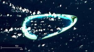
| LANDSAT image of the Goidhoo Atoll | ||
| Waters |
Lakkadive Sea (Indian Ocean) |
|
| archipelago | Maldives | |
| Geographical location | 4 ° 51 ′ N , 72 ° 55 ′ E | |
|
|
||
| Number of islands | 4th | |
| Main island | Goidhoo | |
| length | 17.9 km | |
| width | 7.7 km | |
| Land area | 1.7 km² | |
| total area | 105 km² | |
| Residents | 811 (2006) | |
| Map of the administrative atoll of Baa , in the south of Goidhoo | ||
The Goidhoo Atoll (also Goidu , Dhivehi ގޮއިދޫ) is a small natural atoll of the Maldives in the administrative district of Baa . It is also known as the Goifulhafehendhu Atoll and Horsburgh Atoll (after the British cartographer James Horsburgh ).
Goidhoo is part of the Maldives' western atoll chain and is located in the northwest of the country about 13 km south of the South Maalhosmadulu Atoll , from where it is administered. The distance to the capital Malé is approximately 100 km.
The atoll has a total area (including the lagoon ) of 105 km², while the land area of the islands combined is only 1.7 km², and a population of 811, which is spread over three inhabited islands: the main island Goidhoo with 503, Fehendhoo with 114 and Fulhadhoo with 194 inhabitants (2006 census).
The atoll is roughly in the shape of a horizontal ellipse open in the south, with the three inhabited islands in the northeast. Another, uninhabited island is Innafushi , there are also a number of sandbanks and coral reefs protruding from the water such as Fareedhaafinolhu , Fehenfushi ( Dhashufaruhuraa ), Fulhadhoorah kairi finonolhu ( Rahkairifinolhu ) and Maafushi ( Mathifaruhuraa ).
Individual evidence
- ↑ Table 3.3: Population by Islands Census 2000, 2006 . ( Memento of March 4, 2016 in the Internet Archive ) In: Statistical Yearbook 2011 , Department of National Planning


