Ihavandhippolhu Atoll
| Ihavandhippolhu Atoll | ||
|---|---|---|
| NASA satellite image by Ihavandhippolhu | ||
| Waters |
Lakkadive Sea (Indian Ocean) |
|
| archipelago | Maldives | |
| Geographical location | 7 ° 1 ′ N , 72 ° 55 ′ E | |
|
|
||
| Number of islands | 23 | |
| Main island | Ihavandhoo | |
| length | 26 km | |
| width | 13 km | |
| Land area | 5,958 km² | |
| total area | 289.81 km² | |
| Residents | 5538 (2006) | |
| Map with the atoll in the northwest | ||
The Ihavandhippolhu Atoll ( Thaana : އިހަވަންދިއްޕޮޅު) is the northernmost atoll in the Maldives .
geography
The atoll is over 110 kilometers south of the Indian island of Minicoy . In between is the Eight Degree Channel , which bears the name of the latitude. It is separated from the south adjoining large atoll Thiladhunmathi-Miladummadulhu (Boduthiladhunmathi) by the 4.5 km wide Gallandu Channel .
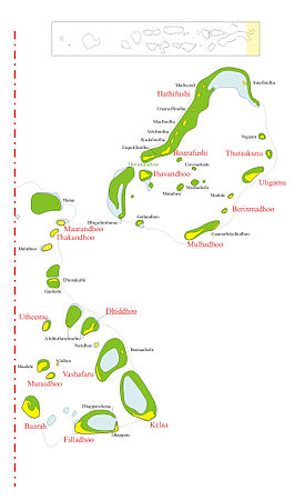
The west side of the atoll consists of two large reef formations that form an almost closed barrier to the open ocean, interrupted only by the South West Entrance. On the larger northern reef are a number of smaller islands. The east side, however, has several openings, with relatively large islands. The eastern half of the lagoon is 37 to 55 meters deep and the western 18 to 37 meters, with numerous shoals especially in the western half.
The atoll has a total area of 289.81 km². On the reef rim of the around 22 km long and up to 11 km wide atoll are 20 islands and three other islands in the lagoon . Only five of the islands are inhabited (Ihavandhoo, Hoarafushi, Thuraakunu, Uligamu, Mulhadhoo). At the 2006 census, Hathifushi was still inhabited, and at the 2000 census, Berinmadhoo was still inhabited. The population of both islands was relocated.
The islands' aggregate land area is 595.8 hectares or 5.96 km². The eponymous main island Ihavandhoo is located in the south of the lagoon, at the South West Entrance, the only passage on the west side of the atoll. It is the southernmost of the inhabited islands. The inhabitants live mainly from fishing and coconut trees.
Islands
![]() Map with all coordinates: OSM | WikiMap
Map with all coordinates: OSM | WikiMap
The islands from north to south:
1) At the 2000 census there were still 124 inhabitants, the population was relocated
2) Currently uninhabited, the population has been relocated
3) Located in the lagoon
4) without vegetation
administration
Administratively, Ihavandhippolhu belongs to the Maldivian administrative atoll ( district ) Thiladhunmathi Uthuruburi ( Haa Alif ), which also includes the northern part of the southeastern neighboring Thiladhunmathi-Miladummadulhu -Atoll.
Individual evidence
- ↑ Oceandots: Ihavandhippolhu ( Memento of 27 September 2012 at the Internet Archive )
- ^ National Geospatial Intelligence Agency: India and the Bay of Bengal. Sailing Directions (Enroute), Pub. 173 (2011) , 5.17 Ihavandiffulu Atoll, p. 127
- ^ Abdulla Naseer: Pre-and post-tsunami coastal planning and land-use policies and issues in the Maldives (Proceedings of the workshop on coastal area planning and management in Asian tsunami-affected countries)
- ↑ Yearbook 2011, Table 3.3: POPULATION BY ISLANDS CENSUS 2000, 2006 ( Memento from March 4, 2016 in the Internet Archive ): Berinmadhoo 124 inhabitants for the 2000 census
- ↑ Isles (of which the larger beach line area specifications were used)
- ↑ Table 1.5: AREA, POPULATION DENSITY AND DISTANCE TO MALE 'AND ATOLL CAPITALS, BY LOCALITY ( Memento from March 23, 2014 in the Internet Archive )
Web links
- Nautical chart section with the Ihavandhippolhu Atoll
- Atoll Travel Information (Dumont Travel Paperback)
- Ministry of Atolls Development: Haa Alifu ( Memento from September 30, 2007 in the Internet Archive ) (with Ihavandippolhu Atoll)


