
Gollinger waterfall
| Gollinger waterfall (Schwarzbachfall) | ||
|---|---|---|
 The lower case |
||
| Coordinates | 47 ° 36 '4.8 " N , 13 ° 8' 12.7" E | |
|
||
| place | On the Göll near Golling and Kuchl , State of Salzburg | |
| height | 100 m | |
| Number of fall levels | 2 | |
| Falling watercourse | underground ( Schwarzbach cave ) | |
| Estuarine waters | Schwarzbach to the Salzach | |

The Golling waterfall , actually Schwarzenbach case or Schwarzenbach case called, is one in Tennengau ( Austria ) on the municipal boundary between Golling on the Salzach and Kuchl situated waterfall . The waterfall is around 100 meters and comes directly from the Schwarzbachfall cave .
Description and development
The Gollinger waterfall, actually two waterfalls one behind the other, is located on the eastern slope of the Göll massif , on the left in the Salzach Valley on Nikolausberg above the pilgrimage church . It has a height of fall of around 75 meters, with the last step being 25 meters high. The upper step is spanned by a natural bridge.
The waterfall gets all of its water from a karst spring , which drains the Göllstock, which is otherwise quite poor in spring, and emerges through the system of the Schwarzbachfall cave. In year-round 5-6 ° C water temperature varies, the bulk of the springing out of the cave Karst source 30-42416 liters per second with an average of 1261 l / s (1999 to 2011 series). The cave fill can also fall dry, and only more water comes from deeper side outlets. It is now considered implausible that the water in the Schwarzbachfall cave came from the Königsee .
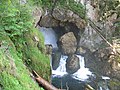
The upper step falls in the cave into a cauldron from which the water drains through a hole in the rock
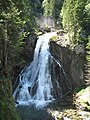
The lower tier

Obelisk at the foot of the waterfall, with an inscription to the nature lover Ernst Schwarzenberg


The waterfall can be climbed from the side via a path (some stairs). The natural spectacle was made accessible as early as the early 19th century.
Joseph Kyselak tells of the Gollinger waterfall in his travel description published in 1829:
“You follow the stream upwards, pass two half-ruined mills that tend to elude the scrutinizing eye under trees, and finally come to a tangle of loose stones, bushes and wounded trees. A narrow path leads to the heavy waterfall that is on the way. An obelisk erected by the nature lover Ernest Fürst von Schwarzenberg ; praises the noble desire of traveling strangers to spot masterpieces of creation. More than that memorial stone, this generous Chevalier praised the paths which he had laid out for studying the Cascades in all the situations in which they were placed. First you come to a rocky canyon, into which the Gulinger or Schwarzabach rushes down for the last time over large rock debris that the ravages of time have polished smooth and completely covered with green mud or moss. Cool air and dusty rain curls the admirer's hair, who, disregarding the wetness, remains in amazement. Trees and rocks have built a bulwark, which forbids to penetrate further. (...)
I left these wonderful cataracts, uncertain whether I should award this or the previously admired Salza ovens the price of curiosity? "
natural reserve
|
Gollinger waterfall natural monument
|
|
| location | Salzburg , Austria |
| Area / extent | 3.008 ha / 300 m |
| Identifier | NDM00197 |
| Geographical location | 47 ° 36 ' N , 13 ° 8' E |
| Sea level | from 506 m to 631 m |
| Setup date | 1985 |
| particularities | also protected cave Schwarzbachhöhle including Schwarzbachfall ( BGH00016 ) |
The area around the waterfall has been designated as a natural monument (flat, NDM 197 ) since 1985 , with 3.0077 hectares . The purpose of protection is beauty as well as rarity. It is also included in the Schwarzbach cave ( BGH No. 16 ), which is designated as a specially protected cave according to the cave protection regulations .
The European and nature reserve Kalkhochalpen (ESG 9 / NSG 12) begins only a few hundred meters away . To connect this natural monument here is a branch of the conservation area, Goll, Hagen, High King Mountain, Steinernes Meer (LSG 30) extending from the waterfall to the borders of Europe reserve.
See also
Web links
Individual evidence
- ↑ Federal Ministry for Agriculture, Forestry, Environment and Water Management (Ed.): Hydrographisches Jahrbuch von Österreich 2011. 119th Volume. Vienna 2013, p. Q35, PDF (12.9 MB) on bmlrt.gv.at (yearbook 2011)
- ↑ a b Harald Huemer: The Gollinger waterfall . In: Federal Ministry of Agriculture, Forestry, Environment and Water Management - Dept. VII 3 Water Management (Ed.): Communications from the Hydrographic Central Office . Source observation in the Hydrographic Service in Austria . Volume 70. Vienna 2005, p. 38–41 ( Online , bmlfuw.gv.at, there p. 44 ff. [PDF; accessed on January 1, 2014]). Online ( Memento of the original from April 24, 2014 in the Internet Archive ) Info: The archive link was inserted automatically and has not yet been checked. Please check the original and archive link according to the instructions and then remove this notice.
- ^ Joseph Kyselak : Sketches of a foot trip through Austria. . Edited by Gabriele Goffriller and with a foreword by Gabriele Goffriller and Chico Klein. Jung und Jung, Salzburg et al. 2009, ISBN 978-3-902497-52-9 (new edition of the unabridged original text from 1829, accompanied by the results of the research project).
- ^ Gollinger waterfall in the nature protection book of the state of Salzburg

Biederer Alpswald (GLT / NWR / EBR) | Bluntautal (GLT) | Brunnecker Cave (BGH) | Göll, Hagen-, Hochköniggeb., Steinernes M. (LSG) | Gollinger Waterfall (NDM) | Gruberhorn cave (BGH) | Kalkhochalpen (ESG / NSG) | Nikolausberg near Golling (GLT) | Rabenstein – Kellau (LSG) | Salzachöfen (NDM) | Schwarzbach cave including Schwarzbachfall (BGH) | Tennengebirge (NSG)
Freimoos in Kuchl (GLT) | Georgenberg near Kuchl (NDM) | Göll, Hagen-, Hochköniggeb., Steinernes M. (LSG) | Gollinger Waterfall (NDM) | Heiligensteiner-Au Kuchl (GLT) | Kalkhochalpen (ESG / NSG) | Rabenstein – Kellau (LSG) | Roßfeldstrasse (LSG) | Schwarzbach cave including Schwarzbachfall (BGH) | Tauglgries (ESG / NSG)