
Salzach ovens
| Salzach ovens | ||
|---|---|---|
 South entrance of the Salzachöfen with state road B159 and Salzburg-Tiroler-Bahn |
||
| location | Salzburg , Austria | |
| Waters | Salzach | |
| Mountains | Tennengebirge / Hagengebirge ( Northern Limestone Alps ) | |
| Geographical location | 47 ° 34 '38 " N , 13 ° 11' 25" E | |
|
||
| Type | Breakthrough valley ( valley pass ) | |
| rock | lime | |
| height | 469 to 492 m above sea level A. | |
| length | 1.5 km | |
| use | Traffic route (country road, train, motorway crosses) | |
| particularities | partly natural monument | |

The Salzachöfen or the Salzachklamm is the gorge-like breakthrough of the Salzach River through the northern limestone Alps between the Hagen and Tennen Mountains .
Sections of it are designated as a natural monument .
Location, landscape and traffic
The Salzachöfen are the gorges of the breakthrough valley of the Salzach with the Lueg Pass . The two names can be used interchangeably for the entire gorge, in the narrower sense the Pass Lueg is a local location and historical fortification in the middle of the gorge, and the Salzachöfen are the lowest and wildest section of the river before the Salzach enters the Alpine foothills at Golling deepens into the Alps here in the Salzburg – Halleiner basin . The entire gorge stretches in an S-shape from south of Golling , where the bridge leads to Ofenau , to north of Werfen- Tenneck ( Stegenwald Fuhr- und Flößerwirtshaus ). It represents the most important connection between the outer mountains and the Salzburg inner mountains .

By car you drive about 30 minutes from Salzburg on the state road B 159 Salzachtal Straße . The double-track electrified Salzburg-Tyrolean railway overcomes this bottleneck through the Ofenau tunnel and then follows the state road. The tunnel solution, the Ofenauer tunnel (1.3 km) and the Hiefler tunnel (2 km), was also chosen for the Tauern Autobahn A10 , the gorge between them being spanned by a bridge tunnel portal to tunnel portal. The narrowing of the Salzach valley begins to the south of the actual gorge. The Tauern cycle path leads along the state road past the gorge. For several kilometers, the state road accommodates the cycle traffic of the Tauern cycle path, which runs south and north of the Salzachöfen next to the state road. Today the motorway also has a junction at Pass Lueg near Stegenwald (Exit 34).
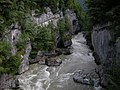
Most of the stretch of the river Salzach is heavily regulated on the right bank , where roads and railways run, while the left bank is completely natural. In the last section, the actual Lueg Pass, the road rises above the river level, and the gorge there is entirely natural and one of the last wild water stretches of the Salzach.

upper entrance to the gorge
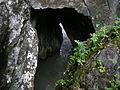
"The cathedral", a buried section of the gorge

just before the southern exit
lower gorge entrance


History and Conservation
|
Salzachöfen natural monument
|
|
 View from the footbridge into the lower gorge area |
|
| location | In Golling on the Salzach , Salzburg |
| surface | 21.24 hectares |
| Identifier | NDM00186 |
| Geographical location | 47 ° 34 ' N , 13 ° 11' E |
| Sea level | from 469 m to 560 m |
| Setup date | 1982 |


Already in the Old , Middle and New Stone Ages , even in the Bronze Age , that is, in a period of around 11,000 years (12,000 BC – 750 BC), there were camps of fishermen and hunters on the banks of the Salzach. At that time, the river bed of the Salzach was 70 meters higher than it is today, as the water cuts deeper and deeper into the gorge.
At the Lueg Pass, less than 200 meters from the gorge, in 1809 the Salzburg freedom fighters under Josef Struber briefly opposed the French-Bavarian troops. The Archdiocese of Salzburg was nevertheless taken by Napoleon's troops.
Joseph Kyselak reports on his visit to the Salza = ovens in 1825:
“When you have pretty much wound your way out of the ravine, you climb a small hill and turn to the left, next to a piece of rock. A pillar with a wooden hand, on which the words: "To the Oefen der Salza," are written, pulls the traveler off the road and tells them to follow the indicated corridor path. Railings and here and there stairs (which Ernest Fürst von Schwarzenberg had generously put in place) lead him initially up and then down again into a rocky gorge that outweighs everything that has been seen so far. One hears thundering and roaring under his feet, feels the trembling of the rocks, and does not dare to guess what is real; to the left a narrow rock crevice yawns, one translates it, and jumped - over the mighty Salzach river, which spreads above and below for a quarter of an hour!
If you do not want to allow yourself this safe swing, you can go a little further to the right on a Brügelweg, with two steps over the Salza, which in the deep abyss penetrates between rocks, and here and there has dug caves (ovens) in the limestone rock through constant penetration . In such abysses, pious believers, at risk of their lives, used to descend on ropes in order to hang up crucifixes or offerings for the Mother of God and other saints. This strange use, which floods, flood of wood or loose stones pursued with hostility, has been dissolved for years, and is limited only to the poor lumberjacks, who, when the trees pile up in the narrow gulf below, have to lower the course with hoes to ventilate the driftwood to Hallein . They were just busy cutting down the pine forest opposite; the trunks have been loosened to make the bark easier to slide away, which is then collected and powdered in mills for use by the fermenters. When a few trunks bumped down against the stones with terrible force, the walls roared as if from the thunder of cannons; The servants, however, with iron on their feet, climbed around with a cold-bloodedness that made them mock all danger. "
In 1982 the remaining whitewater section was designated as a natural monument ( NDM 186 ). It covers 21.2437 hectares on both sides of the gorge from the Ofenauer bridge to about the middle of the breakthrough valley at the level of the old road tunnel.
Recreational use
The gorge, which is up to 90 meters deep, is easily accessible to pedestrians via a path with stairs. It has been a very popular natural attraction since the beginning of the 19th century.
As extreme white water (with a flow speed of up to 30 km / h) it is popular with canoeists, although some canoeists have already lost their lives. The first canoeist who entered the gorge in 1931 was called Adolf Aderle . The inspection took place with a folding boat .
The Salzach can reach a water depth of up to 60 meters at the narrowest gorge spots.
literature
- The "Oefen" in the Salzburg Mountains . In: The Gazebo . Issue 7, 1866 ( full text [ Wikisource ]).
Web links
Individual evidence
- ↑ Sketches of a walking tour through Austria, Styria, Carinthia, Berchtesgaden, Tyrol and Bavaria to Vienna - along with a romantic and picturesque depiction of several knight's castles and their folk tales, mountain areas and ice glaciers on this hike, undertaken in 1825 by Joseph Kyselak , here: Vol. 1 , P. 131 f.
- ^ Notice of July 1, 1982; Number 441-370 / 21-1979
- ^ Salzachöfen in the nature conservation book of the state of Salzburg

Biederer Alpswald (GLT / NWR / EBR) | Bluntautal (GLT) | Brunnecker Cave (BGH) | Göll, Hagen-, Hochköniggeb., Steinernes M. (LSG) | Gollinger Waterfall (NDM) | Gruberhorn cave (BGH) | Kalkhochalpen (ESG / NSG) | Nikolausberg near Golling (GLT) | Rabenstein – Kellau (LSG) | Salzachöfen (NDM) | Schwarzbach cave including Schwarzbachfall (BGH) | Tennengebirge (NSG)