
Gorak Shep
| Gorak Shep | |||
|---|---|---|---|
|
|||
| Coordinates | 27 ° 59 ′ N , 86 ° 50 ′ E | ||
| Basic data | |||
| Country | Nepal | ||
| Province No. 1 | |||
| ISO 3166-2 | NP-P1 | ||
| District | Solukhumbu | ||
| height | 5207 m | ||


Gorak Shep is the last permanently inhabited place ( VDC Khumjung ) before the southern ascent to Mount Everest via the Valley of Silence ("Western Cwm").
It is located at an altitude of 5207 m and directly on the Khumbu Glacier , which flows past Mount Everest to the east of the town in a south-westerly direction. The village consists of several hostels (lodges).
The village takes its name from the so-called Gorak chickens . These partridge-like animals are the subject of a little legend : after consuming poisonous plants, they fly up to the height of the summit of Mount Everest and then get rid of the poison in free fall.
The 5545 m high Kala Patthar , one of the most popular viewpoints in the Khumbu, rises directly from an old lake bed on the outskirts .
- Gorakshep

Kala Patthar in front of Pumori-Lingtren-Khumbutse

Away from Lobuche
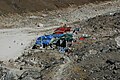
Lodges in all colors
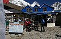
Lodge in Gorak Shep

From the Kala Patthar
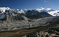
Khumbu glacier


Web links
Individual evidence
- ^ National Geographic Information Infrastructure Program, Index of Geographical names of Nepal 2007 (p. 6). ( Memento of the original from July 4, 2009 in the Internet Archive ) Info: The archive link was automatically inserted and not yet checked. Please check the original and archive link according to the instructions and then remove this notice. (PDF; 52 kB)