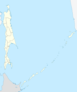
Gornozavodsk (Sakhalin)
| Village
Gornozavodsk
Gornozavodsk
|
||||||||||||||||||||||||||||||||
|
||||||||||||||||||||||||||||||||
|
||||||||||||||||||||||||||||||||
Gornosavodsk ( Russian Горнозаво́дск ) is a village in Sakhalin Oblast ( Russia ) with 4,389 inhabitants (as of October 14, 2010).
geography
The village is located on the southwest coast of Sakhalin Island Sakhalin , 80 kilometers (distance) southwest of the Oblasthauptstadt Yuzhno-Sakhalinsk . The place belongs to Nevelsk Raion , whose administrative center, the city of Nevelsk , is a good ten kilometers away in a northerly direction.
Gornozavodsk stretches from the coast several kilometers up the valley of the Lopatinka river.
history
The place was founded before 1905 when the southern part of the Sakhalin Island was under joint Russian-Japanese administration. He called himself Naihoro ( Japanese 内 幌 町 , - chō ), derived from the Ainu words for "deep valley". From 1905 to 1945 Naihoro belonged to Japan after the Treaty of Portsmouth , which ended the Russo-Japanese War 1904–1905. As a result of the Second World War , the city came back to the Soviet Union and in 1947, under its current name, was given Soviet town charter (Russian for mining town , in relation to coal production ).
After the population had decreased continuously since the 1950s and significantly in the 1990s, Gornosavodsk lost its city status in 2004 and has been a rural settlement ever since.
Population development
| year | Residents |
|---|---|
| 1941 | 10,957 |
| 1959 | 11,250 |
| 1970 | 9,283 |
| 1979 | 8,649 |
| 1989 | 9,070 |
| 2002 | 6,051 |
| 2005 | 4,389 |
Note: census data
Economy and Infrastructure
After hard coal mining came to a standstill in the 1990s, there is only a small amount of building material industry left today. In addition, the population is engaged in fishing and fur hunting in the practically uninhabited hinterland of the place, towards the southern tip of Sakhalin.
The place is on the narrow-gauge railway line ( cape gauge 1067 mm) running along the west coast of the island Ilyinsk - Shebunino (station Shakhta-Sakhalinskaya ). The regional road R496 runs through the village , which also runs along the west coast of Kholmsk in a southerly direction via Nevelsk to Schebunino.
Individual evidence
- ↑ a b Itogi Vserossijskoj perepisi naselenija 2010 goda. Tom 1. Čislennostʹ i razmeščenie naselenija (Results of the All-Russian Census 2010. Volume 1. Number and distribution of the population). Tables 5 , pp. 12-209; 11 , pp. 312–979 (download from the website of the Federal Service for State Statistics of the Russian Federation)
Web links
- Gornosavodsk on mojgorod.ru (Russian)

