Gravesend
| Gravesend | ||
|---|---|---|
| Coordinates | 51 ° 27 ' N , 0 ° 22' E | |
| OS National Grid | TQ647740 | |
|
|
||
| Residents | 55,467 (as of 2011) | |
| administration | ||
| Post town | GRAVESEND | |
| ZIP code section | DA11-DA12 | |
| prefix | 01474 | |
| Part of the country | England | |
| region | South East England | |
| District | Borough of Gravesham | |
| Civil Parish | unparished area | |
| British Parliament | Gravesham | |
| Website: www.visitgravesend.co.uk | ||
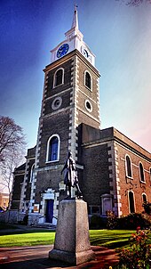
Gravesend is a port town in Kent in England on the south bank of the Thames with about 55,500 inhabitants (as of 2011). It is the administrative seat of the Borough of Gravesham .
history
Since the 15th century, passengers from Gravesend have been able to get to London by ship, and Gravesend has had town charter since 1562. The main products include paper, cement and rubber products. In 1617 the Indian Pocahontas died here on her way home . The name is derived from the English grove (forest) and end (end). In the Domesday Book (1086), however, the village is called Gravesham (home of the count).
The Gravesend – Tilbury ferry across the Thames connects with Essex . Gravesend has a pilot station to support shipping on the Thames.
Daughters and sons
- Sir Derek Barton (1918–1998), winner of the Nobel Prize in Chemistry
- Sir Peter Blake (born 1932), artist
- Robert Grange (1938-2018), British actor
- Katharine Hamnett (* 1947), fashion designer
- Karen Vousden (* 1957), cancer researcher
- Gemma Arterton (born 1986), actress
See also
Web links
Commons : Gravesend - collection of images, videos and audio files
Individual evidence
- ^ Judith Glover: The Place Names of Kent . Meresborough Books, Kent 1982, ISBN 0-905270-61-4 (reprinted from Batsford 1976 edition).

