
Griesgundkopf
| Griesgundkopf | ||
|---|---|---|
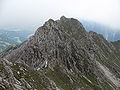
 From the Stillachtal with Schartenkopf (1,977 m) |
||
| height | 2164 m above sea level NHN | |
| location | Bavaria , Germany | |
| Mountains | Southeastern Walsertal Mountains , Allgäu Alps | |
| Dominance | 0.2 km → Alpgundkopf | |
| Notch height | 36 m ↓ notch to the Alpgundkopf | |
| Coordinates | 47 ° 19 '24 " N , 10 ° 14' 19" E | |
|
||
| rock | Main dolomite | |
| First ascent | by locals | |

The Griesgundkopf is a 2164 m high mountain peak in the Allgäu Alps .
Location and surroundings
It is the northeasternmost peak of the Schafalpenköpfe group and lies northeast of the Alpgundkopf . North of the Griesgundkopf lies the touristically insignificant Schartenkopf , from which the Griesgundkopf is separated by the Griesgundscharte .
Ascent
There is no marked path leading to the Griesgundkopf. It can be reached without a path either from the south-east from the path to Guggersee or from the north-west from the Warmatsgund valley . Both climbs require surefootedness and mountain experience. The direct ascent in the fall line of the summit from the northwest is dangerously not to be recommended because of the fragile rock.
Summit cross
In 1987 a summit cross was erected on the Griesgundkopf . The summit cross was renewed in July 2011 through a private initiative by three people on their own after the old cross was badly damaged by the weather.
photos
Summit construction from the Alpgundkopf

From the northwest

With Alp- and Griesgundkopf


literature
- Thaddäus Steiner : Allgäuer Bergnames , Lindenberg, Kunstverlag Josef Fink, 2007, ISBN 978-3-89870-389-5
- Thaddäus Steiner: The field names of the municipality of Oberstdorf im Allgäu , Munich, self-published by the Association for Field Name Research in Bavaria, 1972
- Zettler / Groth: Alpine Club Guide Allgäu Alps . Bergverlag Rudolf Rother , Munich 1984. ISBN 3763311114
Web links
Individual evidence
- ^ Fritz Gelhard: The summit cross on the Griesgundkopf . Contribution to the annual report of the DAV section Oberstdorf, 1987.