Grimmaischer Steinweg
| Grimmaischer Steinweg | |
|---|---|
| Street in Leipzig | |
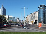
| The Grimmaische Steinweg from Augustusplatz from the east (2011) | |
| Basic data | |
| place | Leipzig |
| District | Center-east, center-southeast |
| Hist. Names | Dresdner Strasse (1839–1863) |
| Connecting roads | Augustusplatz, Johannisplatz |
| Cross streets | Nürnberger Strasse, Querstrasse |
| use | |
| User groups | Pedestrian traffic , bicycle traffic , car traffic , public transport |
| Technical specifications | |
| Street length | 0.2 km |
The Grimmaische Steinweg is a main thoroughfare in Leipzig and one of the most important connections to the inner city ring .
course
The Grimmaische Steinweg runs in an east-west direction and connects the Johannisplatz with the Augustusplatz . The Grassimuseum forms its eastern line of sight , the new Paulinum on Augustusplatz to the west .
The length of the street is 222 meters. It has two or three lanes in both directions and has a separate track bed for the Leipzig tram . Lines 4, 7, 12 and 15 run through the Grimmaische Steinweg. There is a shared walking and cycling path on both sides.
The Grimmaische Steinweg forms the border between the districts center-east and center-southeast.
history
The Grimmaische Steinweg follows the historical course of the Via Regia , an old west-east trade route that crossed the Via Imperii in Leipzig . Starting from the market , the inner-city section of the Altstrasse continues to this day as Grimmaische Strasse to the place of the former city wall . Its continuation beyond the city fortifications was the Grimmaische Steinweg. At the east of the four Leipzig city gates , the Grimmaischer Tor, the Via Regia left the city in an easterly direction. In the late Middle Ages, the path between the Grimmaischer Tor and the Weichbild boundary was paved with stone paving , which led to the name Grimmaischer Steinweg. Initially there were only three such stone- paved arterial roads in Leipzig, the Grimmaischen Steinweg , the Peterssteinweg and the Ranstädter Steinweg .
With the expansion of the city, the Grimmaische Steinweg was also built and thus belonged to the eastern suburb . These suburbs were often badly affected by acts of war or even burned down by their own military to allow gunfire freedom. This happened with the construction of the Grimmaischen Steinweg in 1546 during the Schmalkaldic War on the orders of Duke Moritz von Sachsen . There was also serious damage during the Thirty Years' War when the city was besieged five times. During the Leipzig Battle of the Nations it came on 18./19. October 1813 to severe devastation along the Grimmaischen Steinweg. The fiercest battles broke out for control of the two city gates that were at the beginning (Grimmaisches Tor) and at the end of the path ("Kohlgärtnertor").

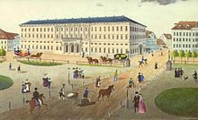
From the 18th century, a largely urban development with trade and commerce emerged in the ground floor zone and the floors above. Notable buildings on the north side were the “Goldenes Einhorn ” inn with a relaxation area in the courtyard and the post office built by Albert Geutebrück (1801–1868) on the corner of Augustusplatz between 1836 and 1838 . Before that, until 1835 the inn "Zum Weisse Schwan" was located here. This and some smaller houses were demolished during the construction of the 87-meter-long classical building of the Leipzig Oberpostdirektion , the main front of which was oriented towards Augustusplatz. Its right (southern) side wing extended along the Grimmaischen Steinweg. The building was rebuilt in the years 1881–1884 in the style of historicism ( neo-renaissance ) (→ main post office ).
On the south side of the Grimmaischen Steinweg, a new construction of the maternity ward and midwifery school of the Trier Institute was built in 1853 ; the architect was also Albert Geutebrück. In 1852 BG Teubner built his one-story house on Grimmaischer Steinweg to the same level as his adjoining company building on Augustusplatz, with which it now formed a single block over several floors.
The Grimmaische Steinweg was part of the Dresdner Straße between 1839 and 1863 , but was renamed again. In 1872 the Leipzig horse tram ran for the first time through the Grimmaischen Steinweg and in 1896 the first electric tram .
During the Second World War , the development on the Grimmaischer Steinweg was almost completely destroyed. The post office building on the north side of the street, which burned out on December 4, 1943 and was rebuilt as a telecommunications office after the war , still existed until it was demolished in 2015 as part of the reconstruction of the main post office . From 1961 to 1964, the post office built the new main post office adjacent to the then telecommunications office; this has been empty since 2011 and has been under reconstruction since 2016. After the fall of the Berlin Wall (1989/90), Telekom built its main building in Leipzig on the corner of Querstraße. The traditional paper shop Flinsch existed for a few years after the war in a building that had been reduced to a flat building. The south side, free of ruins, was used to widen the road. At the corner of Augustusplatz, the then so-called Hotel “Deutschland” was built in the early 1960s, which was soon renamed “Interhotel Am Ring” and was part of the Interhotel chain in the GDR . A corresponding low-rise building stretched along the Grimmaischer Steinweg and was demolished in the course of the renovation of the building into what is now the “Radisson Blu Hotel” (formerly the “Mercure” hotel). The main building of the municipal waterworks Leipzig (KWL) is located about halfway along the southern side of the street and back to Johannisgasse .
- Views and buildings on the Grimmaischen Steinweg
South side of the street:
Triersches Institut , around 1860South-west side of the street:
between Trierschem Institut and Augustusplatz , around 1890Grimmaischer Steinweg from Augustusplatz in the direction of Johanniskirche , the main post office on the left , around 1900
The same view on the ground,
on the left the Reformation monument ,
around 1900
Individual evidence
- ↑ a b The "official" length counts the two separate lanes individually and comes to 444 meters according to the street section directory of the city of Leipzig, traffic and civil engineering office, as of March 1, 2011 (inventory according to § 4 Sächsisches Straßengesetz - SächsStrG - from 21. January 1993).
- ↑ Birgit Hartung: Albert Geutebrück. Builder of Classicism in Leipzig . Lehmstedt-Verlag, Leipzig 2003, ISBN 3-937146-05-9 , p. 71 ff., P. 142
- ↑ BGTeubner Foundation: Teubner office building Augustusplatz / Grimmaischer Steinweg.
- ↑ Gina Klank; Gernot Griebsch: Lexicon of Leipzig street names. Verlag im Wissenschaftszentrum Leipzig, Leipzig 1995, ISBN 3-930433-09-5 , p. 90
- ↑ Air raid on the Reichsmesse city of Leipzig on December 4, 1943, preliminary official final report of December 30, 1943. In: Mark Lehmstedt (Ed.): Leipzig brennt. The downfall of old Leipzig on December 4, 1943 in photographs and reports. Lehmstedt Verlag, Leipzig 2003, ISBN 3-937146-06-7 , pp. 201–227 (208)
literature
- Horst Riedel: Stadtlexikon Leipzig from A to Z . PRO LEIPZIG, Leipzig 2005, ISBN 3-936508-03-8 .
- Wolfram Sturm: History of the Leipziger Post from the beginning to the present . Edited by PRO LEIPZIG, Leipzig 2007, ISBN 978-3-936508-28-4
Web links
Coordinates: 51 ° 20 ′ 18.2 ″ N , 12 ° 23 ′ 0.4 ″ E


