
Grossenbehringen
|
Grossenbehringen
Municipality Hörselberg-Hainich
Coordinates: 51 ° 1 ′ 19 ″ N , 10 ° 31 ′ 42 ″ E
|
||
|---|---|---|
| Height : | 282 m above sea level NN | |
| Incorporation : | July 1, 1950 | |
| Incorporated into: | Behringen | |
| Postal code : | 99820 | |
| Area code : | 036254 | |
Location of Großenbehringen in Thuringia |
||
 Behringen Castle
|
||

Großenbehringen a former municipality in Thuringia , which today forms the western part of the Behringen district of the municipality of Hörselberg-Hainich in the Wartburg district.
location
The district is located on the southeast edge of the Thuringian Basin , bordering the Großenbehringer Holz in the west . To the north and west is the Hainich National Park . To the east joins Oesterbehringen ; both settlement cores have grown together. The federal highway 84 leads through the district and offers a connection to the federal highway 4 about 5 kilometers south of the village . The district of Hütscheroda is to the west of the district .
history
On June 1, 932, Großenbehringen was first mentioned in a document.
From the end of the 13th century until the end of the secularization of the monastery property in the 16th century, the Wettins established a state administration and the establishment of administrative districts. Here, the Behringen places north of the Nesse went to the Gotha office ; at the same time, the majority of them came under the direct administration of the von Wangenheim noble family ( Wangenheim court ) as aristocratic types .
On May 1, 1890, Großenbehringen was connected to the railway network and became the end point of the Nessetalbahn . After the Second World War, the line was closed on September 15, 1947 and dismantled as a reparation payment. On July 1, 1950, Großenbehringen, Oesterbehringen and Wolfsbehringen merged to form the municipality of Behringen .
Attractions
- Behringen Castle
- Local museum
- Castle park with white pine ; a landmark of the place Behringen.

Local history museum in the former inspector's house

Court Square, southeast of the castle

church
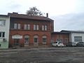
The former train station


Personalities
- Ernst Wilhelm Wolf (1735–1792), court conductor, pianist and composer
Web links
Individual evidence
- ^ Wolfgang Kahl: First mention of Thuringian towns and villages. A manual. Rockstuhl Verlag, Bad Langensalza, 2010, ISBN 978-3-86777-202-0 , p. 100
- ↑ Hans-Stephan Brather: The spatial scope of the Gothaische Ämter in: Der Friedensstein Gotha 1962 issue 4. S. 87-98.
- ↑ Municipalities 1994 and their changes since January 1, 1948 in the new federal states , Metzler-Poeschel publishing house, Stuttgart, 1995, ISBN 3-8246-0321-7 , publisher: Federal Statistical Office