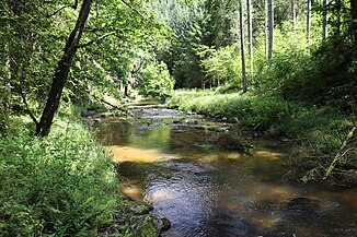
Great Kösslbach
| (Big) Kösslbach or Kößlbach | ||
|
Kösslbach between Schardenberg and Esternberg |
||
| Data | ||
| location | Upper Austria | |
| River system | Danube | |
| Drain over | Danube → Black Sea | |
| source |
St. Roman 48 ° 29 ′ 3 ″ N , 13 ° 40 ′ 36 ″ E |
|
| muzzle |
Freinberg coordinates: 48 ° 34 '10 " N , 13 ° 32' 59" E 48 ° 34 '10 " N , 13 ° 32' 59" E
|
|
| Left tributaries | Koglbach, Kreuzbach, Kl. Kößlbach, Roßbach | |
| Right tributaries | Augbach, Lanzendorfer Bachl, Gersdorfer Bachl, Riedlbach | |
| Communities | St. Roman , Münzkirchen , Schardenberg , Freinberg , Esternberg | |
The Kösslbach (also in the spelling Kößlbach , Großer K. also in contrast to the Kösslbach (Kesselbach) at Wesenufer ) is a medium-sized brook to the Danube with a length of around 15 km in the Sauwald , a wooded area in north-western Upper Austria , not far from the Bavarian border.
The brook rises in the village of Simling in the municipality of St. Roman am Feichtberg , flows to Schönbach, a village in the municipality of Schardenberg , north of Münzkirchen, in a north-westerly direction over the Sauwald plateau. It then bends to the north and reaches the mouth through the Kößlgraben , which also forms the municipality boundary between Freinberg and Esternberg , where it flows into the Danube about 8 km southeast of Passau near the village of Unteresternberg in the municipality of Esternberg.
The underflow of the stream lies in Europe reserve Upper Danube and Aschachtal , and belongs to the Upper Austrian planning unit Donau gorge and side valleys .
The river is also used to generate electricity. The Kneiding small hydropower plant is located near Schönbach .
At the exit of the Kösslgraben is the Königstein ruin (Ecker G'schlössl) , a guard castle that only existed briefly from 1410 to 1436.
Web links
Individual evidence
- ^ ÖK 50, Federal Office for Metrology and Surveying, Map 1
- ↑ Digital Upper Austrian Room Information System (DORIS), Map 1
- ↑ The Danube gorge and side valleys as a unit . In: Office of the Upper Austrian Provincial Government, Nature Conservation Department (Hrsg.): Nature and Landscape / Leitbilder für Oberösterreich (NaLa) . tape 19 . Lochen / Linz 2004, A5.4 Water system , p. 23 ( land-oberoesterreich.gv.at [PDF; accessed October 31, 2019] revised 2007).
- ↑ Digital Upper Austrian Room Information System, Map 2
