Gross Leckihorn
| Gross Leckihorn | ||
|---|---|---|
|
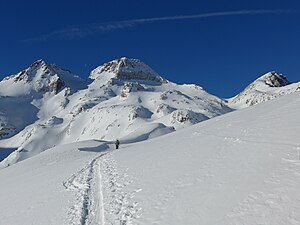
Gross Leckihorn from the northeast, on the left the Chli Leckihorn, on the right the Stellibodenhorn |
||
| height | 3068 m above sea level M. | |
| location | Border canton Uri / canton Wallis , Switzerland | |
| Mountains | Gotthard massif | |
| Dominance | 1.05 km → Witenwasserenstock | |
| Notch height | 222 m ↓ Muttenlücke | |
| Coordinates | 678 658 / 154370 | |
|
|
||
| Normal way | from the Rotondo hut via the Leckipass and the north ridge | |
The Gross Leckihorn ( 3,068 m above sea level ) is a peak in the Gotthard massif in the Lepontine Alps . A little more than 300 meters southeast of it is the Chli Leckihorn ( 3023 m above sea level ). Both summit points are located in the border ridge of the Swiss cantons Uri and Wallis .
Lecki is the Swiss-German name for a lick , the name of the mountain is probably due to the fact that salt was scattered nearby for chamois or goats.
Location and surroundings
The Gross Leckihorn is located in the western part of the Gotthard massif, 5.5 kilometers southeast of the Furka Pass and about 8 kilometers west-southwest of the Gotthard Pass . The summit of the Gross Leckihorn sends three ridges: to the north, to the Leckipass ( 2891 m ), to the southwest to the Muttenpass ( 2909 m ) and to the southeast to the Witenwasserenpass ( 2805 m ). The south-west and south-east ridge form the canton border between Uri in the north and the Valais in the south. In the southeast ridge, the Chli Leckihorn rises a little more than 300 meters away, the deepest notch between the main and secondary peaks is 2967 m .
West of the Leckihorn is the nutrient area of the Mutten Glacier , which flows northwest on the north side of the Muttenhorn . To the east of the mountain lies the Witenwasseren glacier , which flows north. Both are smaller glaciers of about the same size; in 2009 an area of just over 0.6 km² was determined for both.
The Furka Base Tunnel passes under the Gotthard massif almost 500 meters northwest of the Gross Leckihorn.
Alpinism
The easiest ascent to the Gross Leckihorn leads from the Rotondo hut over the Leckipass and the north ridge. The degree of difficulty is indicated in the SAC mountain and high-altitude tour scale with L (easy), the time required is around two hours. The ascent via the Chli Leckihorn is considerably more difficult. and the southeast ridge. Starting from the Witenwasserenpass, climbing difficulties up to UIAA IV- have to be mastered.
The Gross Leckihorn is often climbed as part of a ski tour. As in summer, the usual ascent takes place via the Rotondo hut, the Leckipass and the north ridge. The ski depot is usually before the last steep slope of the north ridge. The degree of difficulty is indicated on the SAC ski touring scale as WS +. For the descent there are several variants with similar difficulty, for example over the Mutten glacier or over the Rottällihorn.
Web links
Individual evidence
- ^ Charles Knapp, Maurice Borel, Victor Attinger, Heinrich Brunner, Société neuchâteloise de geographie (editor): Geographical Lexicon of Switzerland . Volume 3: Krailigen - Plentsch . Verlag Gebrüder Attinger, Neuenburg 1905, p. 103, keyword Gross Leckihorn ( scan of the lexicon page ).
- ^ WGMS: Fluctuations of Glaciers Database. World Glacier Monitoring Service, Zurich 2016 ( DOI: 10.5904 / wgms-fog-2016-08 ), accessed on February 23, 2017
- ↑ Map excerpt from geo.admin.ch , accessed on February 23, 2017
- ↑ a b gipfelbuch.ch: Summit Book - Tour Guide - Gross Leckihorn, 3068 m.a.s.l. Retrieved February 23, 2016.
- ↑ gps-tracks.com: Gross Leckihorn - ski tour. Retrieved on

