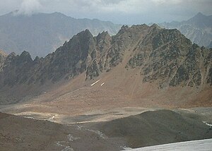
Grubenkarspitze (Ötztal Alps)
| Grubenkarspitze | ||
|---|---|---|
|
Grubenkarspitze from the west |
||
| height | 3000 m above sea level A. | |
| location | Tyrol , Austria | |
| Mountains | Ötztal Alps | |
| Dominance | 1 km → Wurmtaler head | |
| Notch height | 117 m ↓ Scharte to the Wurmtaler head | |
| Coordinates | 46 ° 56'36 " N , 10 ° 49'7" E | |
|
|
||
| First ascent | July 8, 1911 by H. Menger, H. Derfflinger and Hans Dobler | |
| Normal way | East ridge ( I ) | |
The Grubenkarspitze is a mountain of the Kaunergrat , a mountain range of the Ötztal Alps . It is almost exactly 3000 meters high (according to other information 3002 meters) and forms the culmination point of the pit ridge, which starts at the Rifflsee and continues southwest to the Wurmtaler Kopf . The Grubengrat limits the Rifflkar to the east. The stubby east ridge of the Grubenkarspitze divides the eastern slopes of the Grubengrat into the Grubenkar and the Rotschliffkar further south. The Grubengrat begins in the northeast with a broad, rounded ridge and continues over rugged, coarse rock towers to the southwest to the Grubenkarspitze.
Routes
The normal route follows the Fuldaer Höhenweg from the Rifflsee to a sheep pasture. From there to the west over grassy slopes up into the Grubenkar, which is framed by the Grubengrat in the background and the east ridge of the Grubenkarspitze. You climb the first scree terraces and head towards the large moraine wall , which you climb near the corner. On the gravel plain south towards the east ridge of the Grubenkarspitze. Over steep scree to a steep plate zone, which you bypass on the left. You reach the ridge to the right of a rock spur via flat spots and blocks. Over the easily passable ridge you can easily get to the summit with Steinmann with a few bypasses.
photos
literature
- Walter Klier : Alpine Club Guide Ötztal Alps . Bergverlag Rudolf Rother, Munich 2006; ISBN 3-7633-1123-8
- Ludwig Obersteiner: Guide through the Ötztal Alps . Reichenstein-Verlag, Vienna 1925


