
Häckergrundbach
| Häckergrundbach | ||
|
|
||
| Data | ||
| Water code | DE : 241358 | |
| location |
Upper Main Hill Country
|
|
| River system | Rhine | |
| Drain over | Main → Rhine → North Sea | |
| origin | Confluence of basic trench and Wildenrother millstream in Obermainischen hills southwest from hackers Berg 50 ° 8 '6 " N , 11 ° 18' 12" O |
|
| Source height | approx. 292 m | |
| muzzle | near Burgkunstadt -Mainklein in the Main Coordinates: 50 ° 7 '24 " N , 11 ° 17' 47" E 50 ° 7 '24 " N , 11 ° 17' 47" E |
|
| Mouth height | approx. 281 m above sea level NN | |
| Height difference | approx. 11 m | |
| Bottom slope | approx. 6.9 ‰ | |
| length | 1.6 km (with Wildenrother Mühlbach 5.62 km) | |
| Catchment area | 14.13 km² | |
The Häckergrundbach (with Wildenrother Mühlbach ) is a good five kilometers long right and northeastern tributary of the Main in Upper Franconia .
course
The Häckergrundbach arises from the confluence of the Grundgraben -Bach and the Wildenrother Mühlbach in the Upper Main Hills , southwest of the Häckerberg . Some see " Wildenrother Mühlbach " as the name for the upper reaches of the Häckergrundbach .
The Grundgrabenbach rises with a source height of about 405 m above sea level. NHN immediately north of Kirchlein , the Wildenrother Mühlbach about one kilometer north of Wildenroth, immediately east of the Spitzberg (517.2 m above sea level) at a source height of about 455 m above sea level. NHN. The Häckergrundbach flows into the Main at Mainklein .
Due to its Y-like or Zwistel -like shape, the brook was called Zwistelbach in the Middle Ages .

Western upper reaches of the Wildenrother Mühlbach, which in turn flows into the Häckergrundbach (near Kirchlein)

Another point of the western upper reaches of the Wildenrother Mühlbach
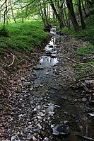
Eastern upper reaches of the Wildenrother Mühlbach (next to Wildenroth Castle )
.jpg)
_II.jpg)
.jpg)
See also
Web links
- Course of the Häckergrundbach on the BayernAtlas
- The catchment area of the Häckergrundbach on the Bavarian Environment Atlas
- Map of the catchment area in the basic data for flowing waters of Bavaria, Bavarian State Office for the Environment
Individual evidence
- ^ Heinz Späth: Geographical Land Survey: The natural spatial units on sheet 141 Coburg. Federal Institute for Regional Studies, Bad Godesberg 1987. → Online map (PDF; 5.0 MB)
- ↑ a b List of brook and river areas in Bavaria - Main river area, page 15 of the Bavarian State Office for the Environment, as of 2016 (PDF; 3.3 MB)
- ↑ The Häckergrundbach in the history of the village of Mainklein , mainklein.de, accessed on April 9, 2011