
Gschnaidt (Altusried)

Gschnaidt is a hamlet and place of pilgrimage in Bavaria , as well as a popular excursion destination. The small settlement essentially consists of two pilgrimage chapels and the Gasthaus zum Kreuz , as well as some stables and farm buildings. Gschnaidt is located in the Oberallgäu district and belonged to the Frauenzell community , which in turn has been part of the Altusried market since the local government reform of 1972 . The Frauenzell community also has representations of the two Gschnaidt chapels in its coat of arms .
description
The Gschnaidt - also Im Gschnaidt , Auf dem Gschnaidt , Auf der Gschnaidt or Auf Gschnaidt - is an 880 m above sea level. d. M. located summit . This is about four kilometers east of Frauenzell and also about four kilometers southwest of Kimratshofen . The “Gschnaidt-Pilgrimage” was first mentioned in 1665, so the two chapels were built up there in later years. The smaller one dates from the 18th century, the larger one from the 19th century. A large black-framed votive picture hangs in the anteroom of the large chapel . It is reminiscent of the so-called snow miracle of 1843, when strange signs were discovered in the snow in March. It is assumed that the snow miracle is an attempt to derive the name Gschnaidt from it has snowed in a folk-naive way . The Way of the Cross is also worth seeing . It leads to a spring version which, according to popular belief, dispenses medicinal water that is particularly intended to help with eye problems. Right next to the chapels is the Forest of Crosses. It is customary, the wooden transition crosses kept after the funeral here. So they stand close together in large numbers and keep the memory alive for a long time. The Gschnaidt is also the starting point for hiking in the state forest, a large forest area with many forest and walking trails.
Directions
Gschnaidt is connected to the regional road network via a communal road. This begins a little south of Kimratshofen where it branches off from the district road OA 14 at the hamlet of Wassergat. From there it leads uphill via the hamlets of Bruderhöfe, Seefeld and Lendraß to Gschnaidt. Gschnaidt is the highest point of the road, after which it falls again and ends after passing the hamlet of Maggmannshofen in the village of Rungatshofen south of Frauenzell - there it is linked to the OA 17 district road. Two more paved access routes begin in Muthmannshofen (on the OA 16) and in Hettisried (on the state road 1308), join in Wendelins and meet at Lendraß on the road described above from the direction of Kimratshofen.

Large and small pilgrimage chapels

Interior of the great Gschnaidt Chapel

Interior of the small Gschnaidt chapel
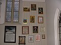
Votive tablets with the snow wonder
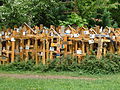
Forest of transition crosses

Large and small Gschnaidt chapel


Web links
- Pilgrimage chapels and the Way of the Cross in Gschnaidt on altusried.de
- www.frauenzell.de with a picture of the coat of arms
- Altusried has history
Individual evidence
- ↑ History, Frauenzell on altusried.de, accessed on November 9, 2016

Altusried | Albrechte | Guardian God | Mountains | Bergs | Betzers | Beaver Swing | Binzen | Bischlagers | Ground roller | Bosses | Fire | Brownlings | Brittlings | Bronnen | Bruderhöfe | Bruggmers | Book | Book adIller | Book | Book a.Wald | Castle | Depsried | Dezion | Diepolz | This stream | Duracherberg | Dürrenbach | Eggarts | Einsiedeln | Ettas | Figlers | Fischer's | Frauenzell | Frohnhofen | Frühstetten | Gaggen | Goose Mill | Geba | Geisemers | Greut | Greuts | Semolina | Grundbühl | Gschnaidt | Guntersthal | Häldele | Heaps | Häuslen | Heckelsmühle | Caves | Hettisried | Hoodless | Hiemen | Hiltensberg | Hinterbrennberg | Hinteregg | Tall wood | Hohentann | Wooden mill | Hörgers | Horns | Lifting fires | Isel | Iselmühle | Kalden | Käsers | Katzenloh | Kempterweg | Kimratshofen | Knaus | Kochs | Kohlstatt | Krugzell | Kühsteig | Dome | Laminets | Lausers | Lendraß | People | Lochhaus | Luiblings | Maggmannshofen | Manzen | Mittelberg | Moss | Mühlengat | Mushans | Muthmannshofen | Naien | Neumühle | Oberegg | Oberhofen | Upper lift | Oberrats | Oberwalzlings | Odach | Oil perennials | Opprechts | Ösch | Osterberg | Ottenstall | Wheel lock | Rich species | Reinthal | Reisers | Ried | Riedlingen | Rorach | Rungatshofen | Discs | Schieten | Schmidberg | Schöneberg | Schorenmoos | Schreiers | Screaming hole | Schwarzenbach | Schwebelhaus | Pig mountain | Schwenden | Seefeld | Singers | Spöck | Staig | Staubers | Climb | Steigberg | Stockers | Stripes | Strobels | Tannschachen | Thannen | Thurn | Ungers | Unteregg | Sub-stroke | Sub-councils | Sawing down | Ursulers | Vocken | Völken | Vorderbrennberg | Forest path | Walkenberg | Walzlings | Washer's | Wasserbühl | Wassergat | Wasting water | Weihalden | Pond | White | Weitenau | Wendelins
Coordinates: 47 ° 47 ' N , 10 ° 8' E