Depsried
|
Depsried
Altusried market
Coordinates: 47 ° 46 ′ 47 ″ N , 10 ° 15 ′ 25 ″ E
|
|
|---|---|
| Height : | 681 m above sea level NN |
| Residents : | 100 (December 21, 2004) |
| Incorporation : | January 1, 1972 |
| Postal code : | 87452 |
| Area code : | 08374 |
|
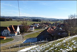
Depsried, view from the west (2016)
|
|

Depsried (formerly also Debsried) is a district of the Altusried market in the Bavarian-Swabian district of Oberallgäu .
geography
The hamlet is located in the Krugzell district , four kilometers southwest of Altusried in the Iselbach valley . Geologically, it is located on a gravelly alluvial fan of the former course of the Iselbach.
history
The Bavarian cadastre shows Depsried in the 1810s as a scattered settlement with nine hearths under the name Döpsried . In 1840 there were twelve houses and 45 souls in the place. The chapel was parish to Krugzell . Only the Chapel of the Visitation of the Virgin Mary , built in 1704, has been preserved as a historical building. See also: List of architectural monuments in Depsried
The former district of Krugzell was incorporated into Altusried as part of the municipal reform on January 1, 1972.
Today the place has about 30 properties with about 100 inhabitants. Many houses were only built after the Second World War due to the immigration of displaced people .
Web links
Individual evidence
- ↑ Geologica Bavarica, Bavarian Geological State Office, 1995, p. 206
- ↑ Döpsried on Bayern Atlas Classical
- ↑ a b Kgl. Bavarian topographical-statistical lexicon 1840
- ↑ LfD list for Altusried (.pdf)
- ↑ Depsried

