
Kimratshofen
|
Kimratshofen
Altusried market
|
|
|---|---|
 |
|
| Height : | 781 m above sea level NN |
| Area : | 23.29 km² |
| Residents : | 1520 (Dec 21, 2005) |
| Population density : | 65 inhabitants / km² |
| Incorporation : | January 1, 1972 |
| Postal code : | 87452 |
| Area code : | 08373 |
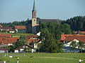
 Kimratshofen, in the foreground Oberhofen
|
|
Kimratshofen is a district of the market Altusried and a district in the Bavarian-Swabian district of Oberallgäu .
location
The parish village is located in the Allgäu , surrounded by fields and meadows, about five kilometers west of Altusried. The city of Kempten (Allgäu) is 24 km, Leutkirch im Allgäu 11 km away. The Kimratshofer Bach , a tributary of the Iller , flows - for the most part piped - through the village.
To Kimratshofen belong the villages or residential areas Behütgott, Bergen, Bischlagers, Bodenwalz, Bossen, Brand, Bronnen, Bruderhöfe, Buchen, Buchen a. Forest, Dezion, Duracherberg, Einsiedeln, Ettas, Greut, Grundbühl, Guntersthal, Häldele, Häuslen, Halden, Hettisried, Heuglosen, wood mill, lift fires, Kempterweg, Kohlstatt, Kühsteig, Mittelberg, Mühlengat, Mushanen, Naien, Neumühle, Oberhofen, Oberwalzlings, Reinthal, Sägmühle (Untersägen), Schieten, Schmidberg, Schorenmoos, Schreiers, Schreiloch, Schweinberg, Schwenden, Seefeld, Spöck, Steigberg, Tannschachen, Ungers, Ursulers, Waldsteig, Walzlings, Wasserbühl, Wassergat, Weitenau and Wies.
history
The West Germanic Alemanni colonized the plain north of Kimratshofen from around 400 AD. Chunibert , a member of them, is said to have founded the place Chumbretzhouven around 766 AD . The name Kunebrechtishoven , which over time became Kimratshofen, is mentioned as a parish in the Liber decimationis in 1275 and in 1353 had a total of 50 apartments. When the Swedes occupied the Allgäu in the Thirty Years' War in 1634, the village and its hamlets almost completely died out due to looting and the plague that broke out at the same time . Of 134 families 31 survived only by the influx of about 50 exiles -families from Tyrol , Vorarlberg and Switzerland , the area revived.
On January 1, 1972, the previously independent municipality of Kimratshofen was incorporated into the Altusried market as part of the municipal reform.
Infrastructure
The Gschnaidt is a popular excursion and pilgrimage destination on a hill 880 m above sea level south-west of Kimratshofen .
Attractions
The parish church of St. Agatha, today's landmark of Kimratshofen, had to be demolished in 1877 due to dilapidation and was rebuilt from 1886 to 1889. Only the base of the tower made of tuff stone blocks remains from the old church building .
traffic
The state road St 2009 leads to Altusried and Legau , the St 1308 to Leutkirch and the district road OA 14 to Kempten. In addition, various municipal roads connect Kimratshofen with the surrounding area.
Famous people
Kimratshofen is connected to the life of Bert Brecht in a special way . His son Frank Banholzer was born here on April 3, 1919 and also spent the first three years of his life here.
Georg Gromer was born in Kimratshofen on March 5, 1883 . The Catholic priest, grammar school teacher and doctor of theology was also politically active in the German Center Party , the Bavarian People's Party and the CSU . From 1946 until his death in 1952 he was a member of the Bavarian State Parliament for the constituency of Neuburg an der Donau . In 1933, Gromer got into trouble because he did not perform the Hitler salute according to the regulations, but instead used the similar greeting from the Bayernwacht . (Source: Bavarian Main State Archive Munich MK 16239).
- Max Ritter von Mulzer , fighter pilot
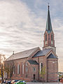
Church from the southeast
Walzlings

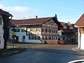
Country inn to the post office
Kimratshofen

Kempter Weg Guntersthal

Kirchberg


Individual evidence
- ^ GenWiki
- ^ Wilhelm Volkert (ed.): Handbook of Bavarian offices, communities and courts 1799–1980 . CH Beck, Munich 1983, ISBN 3-406-09669-7 , p. 496 .
Web links

Altusried | Albrechte | Guardian God | Mountains | Bergs | Betzers | Beaver Swing | Binzen | Bischlagers | Ground roller | Bosses | Fire | Brownlings | Brittlings | Bronnen | Bruderhöfe | Bruggmers | Book | Book adIller | Book | Book a.Wald | Castle | Depsried | Dezion | Diepolz | This stream | Duracherberg | Dürrenbach | Eggarts | Einsiedeln | Ettas | Figlers | Fischer's | Frauenzell | Frohnhofen | Frühstetten | Gaggen | Goose Mill | Geba | Geisemers | Greut | Greuts | Semolina | Grundbühl | Gschnaidt | Guntersthal | Häldele | Heaps | Häuslen | Heckelsmühle | Caves | Hettisried | Hoodless | Hiemen | Hiltensberg | Hinterbrennberg | Hinteregg | Tall wood | Hohentann | Wooden mill | Hörgers | Horns | Lifting fires | Isel | Iselmühle | Kalden | Käsers | Katzenloh | Kempterweg | Kimratshofen | Knaus | Kochs | Kohlstatt | Krugzell | Kühsteig | Dome | Laminets | Lausers | Lendraß | People | Lochhaus | Luiblings | Maggmannshofen | Manzen | Mittelberg | Moss | Mühlengat | Mushans | Muthmannshofen | Naien | Neumühle | Oberegg | Oberhofen | Upper lift | Oberrats | Oberwalzlings | Odach | Oil perennials | Opprechts | Ösch | Osterberg | Ottenstall | Wheel lock | Rich species | Reinthal | Reisers | Ried | Riedlingen | Rorach | Rungatshofen | Discs | Schieten | Schmidberg | Schöneberg | Schorenmoos | Schreiers | Screaming hole | Schwarzenbach | Schwebelhaus | Pig mountain | Schwenden | Seefeld | Singers | Spöck | Staig | Staubers | Climb | Steigberg | Stockers | Stripes | Strobels | Tannschachen | Thannen | Thurn | Ungers | Unteregg | Sub-stroke | Sub-councils | Sawing down | Ursulers | Vocken | Völken | Vorderbrennberg | Forest path | Walkenberg | Walzlings | Washer's | Wasserbühl | Wassergat | Wasting water | Weihalden | Pond | White | Weitenau | Wendelins