Guaynabo
| Guaynabo | |
|---|---|
 Federal prison |
|
 flag |
|
| Location of Guaynabo within Puerto Rico | |
| Basic data | |
| Foundation : | 1769 |
| State : | United States |
| Outside area : | Puerto Rico |
| Coordinates : | 18 ° 21 ′ N , 66 ° 7 ′ W |
| Time zone : | Atlantic Standard Time ( UTC − 4 ) |
| Residents : | 97,924 (as of 2010) |
| Population density : | 1,370.9 inhabitants per km 2 |
| Area : | 71.43 km 2 (approx. 28 mi 2 ) |
| Height : | 47 m |
| Postcodes : | 00965 - 00971 |
| Area code : | +1 787 939 |
| FIPS : | 72-32522 |
| GNIS ID : | 1610863 |
| Website : | www.guaynabocity.gov.pr |
| Mayor : | Hon. Héctor O'Neill García ( PNP ) |
With almost 100,000 inhabitants, Guaynabo is the sixth largest city in the US suburb of Puerto Rico , an island state associated with the United States . It was founded in 1769 by Pedro R. Davila and belongs to the metropolitan area of San Juan .
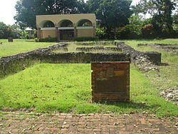
The earliest founding of Puerto Rico Caparra, dating back to 1508, is located in the area of the city . The founder of the settlement, which is now only in ruins, was Juan Ponce de León .
Economically, the city is a center for telecommunications (AeroNet, Claro, Worldnet) and also houses the headquarters of some well-known technology companies ( American Airlines , Dell Technologies , Microsoft , Chevron Corporation ).
City structure
Guaynabo, including the old town of Guaynabo Pueblo, is divided into ten municipal districts ( barrios ), which are further divided into sectores :
| # | Parish (barrio) |
Land area ( km² ) |
Population 2010 |
|---|---|---|---|
| 1 | Guaynabo Pueblo | 1.53 | 4008 |
| 2 | Camarones | 6.32 | 5626 |
| 3 | Frailes | 10.57 | 32050 |
| 4th | Guaraguao | 4.53 | 4178 |
| 5 | Hato Nuevo | 9.01 | 4114 |
| 6th | Mamey | 6.35 | 3103 |
| 7th | Pueblo Viejo | 12.33 | 23816 |
| 8th | Rio | 4.84 | 2791 |
| 9 | Santa Rosa | 9.58 | 16904 |
| 10 | Sonadora | 6.76 | 1334 |
| Guaynabo (city) | 71.43 | 97924 | |
| Source: | |||
Sons and daughters
- Victor Callejas (* 1960), boxer
- Alberto Figueroa Morales (* 1961), Roman Catholic clergyman, auxiliary bishop in San Juan
- Juan Nazario (born 1963), boxer
- David Sánchez (* 1968), jazz musician
- Josue Camacho (* 1969), boxer
- Iván Calderón (* 1975), boxer
- Walter Hodge (* 1986), basketball player
See also
Individual evidence
- ↑ Departamento de Comercio de los EE.UU., Administración de Economía y Estadísticas, NEGOCIADO DEL CENSO DE LOS EE.UU: Censo 2010, Puerto Rico (PDF), p. 22 (square miles converted to km²)


