Guercif
| Guercif جرسيف ⴳⴰⵔⵙⵉⴼ |
||||
|---|---|---|---|---|
|
||||
| Basic data | ||||
| State : |
|
|||
| Region : | Oriental | |||
| Province : | Guercif | |||
| Coordinates | 34 ° 13 ′ N , 3 ° 21 ′ W | |||
| Residents : | 90,880 (2014) | |||
| Area : | 24.74 km² | |||
| Population density : | 3,673 inhabitants per km² | |||
| Height : | 378 m | |||
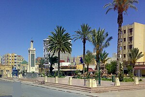
| Downtown Guercif | ||||
Guercif ( Arabic جرسيف, Tarifit ⴳⴰⵔⵙⵉⴼ ) is a large Moroccan city with around 115,000 inhabitants in the Oriental region . It is the capital of the Guercif province of the same name .
Location and climate
Guercif lies between the eastern foothills of the Rif Mountains in the north and those of the Middle Atlas in the south at an altitude of approx. 360 m . The Oued Moulouya , one of the longest rivers in Morocco and the only larger one that flows into the Mediterranean, flows through the city . Here the west-east connection road N6 intersects with the important north-south connection N15. The city is also connected to the Rabat - Fès - Oujda (A2) motorway, which was completed in 2011 and runs around 10 km to the north . The next larger cities are Taza (driving distance approx. 68 km) or Fès (approx. 190 km) in the west and Nador (almost 135 km) in the north and Oujda (approx. 165 km) in the northeast. The climate in Guercif is semi-desert; Rain (approx. 225 mm / year) falls mainly in the winter half-year.
population
| year | 1994 | 2004 | 2014 |
| Residents | 41,997 | 57,307 | 90,880 |
Well over 80% of the population are of Berber descent; speak Central Atlas Tamazight and Moroccan Arabic . The rapid population increase in the last few decades is primarily due to the migration of mountain people to the larger cities.
In 1950 Guercif had about 3,600 inhabitants - including 360 Europeans (mostly French), 2,835 Moroccans (about half Arab and Berbers ) and 460 Jews. In 1964 the city had about 5,500 inhabitants; In 2014 there were already 90,880.
economy
At the center of economic activity is still agriculture, in which - in addition to the cultivation of grain (barley and wheat) - olive cultivation plays a major role. In its role as provincial capital and regional center, administration, health care as well as education and transport are of central importance for the economic life of the city.
history
In the first millennium AD, the Taza depression was a transit area for Roman and Arab-Islamic armies. Otherwise, the Taza-Guercif region only played an important role at the time of the conflict between Almohads and Merinids in the late 13th century. The Merinid Sultan Abu Said Utman II (r. 1310-1331) had the then small town surrounded by a wall of rammed earth, but nothing has survived. In the 18th century, an Alavid sultan built a fortress ( kasbah ) made of rammed earth in the city at that time .
Attractions
There are no more traces of the only sight of historical or cultural importance, the Kasbah . The city center makes a more modern impression overall.
Web links
- History of the Guercif region (French)


