
Gussriegelstrasse
| Gussriegelstrasse | |
|---|---|
|
|
|
 |
|
| Street sign with the old spelling Gussriegelstraße | |
| Basic data | |
| place | Vienna |
| District | Favoriten (10th district) |
| Created | 1904 |
| Cross streets | Quellenstrasse , Buchengasse , Rotenhofgasse, Davidgasse , Inzersdorfer Strasse, Angeligasse , Hardtmuthgasse, Troststrasse , Graffgasse, Brunnweg, Raxstrasse |
| Places | Stefan-Fadinger-Platz |
| Buildings | Starhemberg barracks |
| use | |
| User groups | Pedestrians , bicycle traffic , car traffic , bus route 65A |
| Technical specifications | |
| Street length | approx. 1170 m |
The cast bar street (until 1999 officially Gußriegelstraße ) is located in the 10th Vienna district, favorites . It was named in 1904 after an old field name.
Location and characteristics
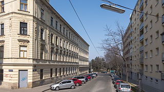
The Gussriegelstraße is located in the western part of Favoritens ( cadastral municipality Inzersdorf-Stadt ) and runs in its northern part parallel to Triester Straße . It extends on the northern slope of the Wienerberg from Quellenstrasse (house numbers 1 and 2) in the north, rising in a southerly direction to Raxstrasse (house numbers 54 and 63), with the course of the road after Troststrasse making a bend in a south-easterly direction. As one of the few connecting streets to Favoriten, it is not a one-way street. The stretch of road south of Troststrasse is used by bus route 65A. Today, the building consists largely of residential buildings from the period after 1945 as well as a few businesses, a barracks and the Fortunapark park.
The beginning of the street at Quellenstraße, heading north

The Gussriegelstrasse at Rotenhofgasse

At Troststrasse

At the Brunnweg

The end of the street at Raxstrasse


buildings

No. 9: Anna-Boschek-Hof
Between Buchengasse and Davidgasse as well as Malborghetgasse and Gussriegelstrasse is a large urban residential complex, which was built between 1953 and 1956 on a previously undeveloped site. The architects Harald Bauer, Josef Bayer, Siegfried Mörth, Rudolf Karl Peschel, Ferdinand Riedl and Fritz Slama were involved in the planning. The complex, which consists of several six-storey building blocks, comprises 415 apartments. There are green spaces between the houses. In 2009 the community building was named after the social democratic trade unionist and politician Anna Boschek . On the corner of Rotenhofgasse there is an obelisk with depictions of animals in mosaic technique, which was created by Heribert Potuznik in 1956 and is a listed building.
No. 20: former Reiss paper mill

The Reiss paper mill was built here in 1908. On an L-shaped floor plan, a five-story, cubic post structure with long fronts arranged with pilaster strips rises . The ground floor is plastered, the rest of the building is made of exposed brick. In the same block around the corner, Davidgasse 85–89, the associated former residential building is located. It is three-story, has a central bay window and beautiful decorative grilles on the windows and between the buildings.
No. 28–30: Harry Glück's residential complex
The house block between Braunspergengasse, Inzersdorfer Straße 113 and Gussriegelstraße consists of a U-shaped residential complex that was built from 1971–1973 according to plans by Harry Glück and Werner Höfer. It is designed in the form of a terrace with up to eight floors, has a white exterior wall coated with concrete varnish and 221 apartments. As Harry Glück realized from 1973 for the Alt-Erlaa residential park , there is a swimming pool on the roof .


No. 33: Fortunapark
In this area there was a popular excursion inn around 1880, Zur Fortuna , after which the park was named in 1976. For a long time, a soccer field was operated on the area that extended to Malborghetgasse and Hardtmuthgasse, and was used by SC Südstern and, from 1919, by FC Nicholson . Much of the tree-lined park is dedicated to children's playgrounds. There is also a demarcated dog zone here.
No. 45–49: Starhemberg barracks
The extensive complex between Gussriegelstrasse, Troststrasse, Malborghetgasse and Graffgasse (a four-storey block edge development) was built in 1911–1912 as the kuk infantry barracks (Franz-Ferdinand-Kaserne) on Erzherzog-Johann-Platz (that was the name of the barracks west of Gussriegelstrasse undeveloped area on which the Eisring Süd is located today) and expanded in 1913. During the Nazi era, the building was named Trostkaserne (after Troststrasse). From 1945 to 1955 the barracks were used by the Soviet occupying forces, whose sector included the 10th district. In 1967 the name was changed to Starhemberg barracks after the defender of Vienna during the Second Turkish Siege of Vienna , Ernst Rüdiger von Starhemberg .
No. 51–59: urban residential complex
Before the construction, there was a large nursery and allotment gardens on the extensive site. Between 1957 and 1959, the urban residential complex was built with two high-rise buildings and 13 apartment blocks with a total of 22 stairs and 454 apartments. The architects Anton Christl, Robert Fussek, Anton Herrgesell, Rudolf Jarosch, Werner John, Günter Krisch, Josef Leitner and Heinz Rollig were involved in the planning. There are spacious green areas, a children's playground and a sports field between the residential buildings. Several works of art were set up in the area, the most important of which is a bronze sculpture Mother and Child by Siegfried Charoux from 1961. There is also a play sculpture of a sea lion made of artificial stone by Franz Waldmüller (1959) and a 3 m high plastic abstraction made of white hard concrete by Herbert Schwarz (1960). At the stairway entrances, 20 ceramic mosaics on the theme of the redesign of the Südtiroler Platz adorn the front doors (the square is the “Entrée” of Favoriten when coming from the city center). Five of them each were created by Johannes Krejci , Heribert Potuznik , Stephan Praschl and Erna Grünseis-Frank around 1960.

Abstraction by Herbert Schwarz

Mosaic renovation of the Südtiroler Platz (1959)

Play sculpture sea lion by Franz Waldmüller

Bronze sculpture mother and child by Siegfried Charoux


No. 52: Penguin Fountain
Walter Leitner's bronze and natural stone penguin fountain , which was built in 1962, is next to the residential complex . The fountain bowl is decorated with fish mosaics.
Metro station
As part of the 2nd part of the expansion project for the U2 / U5 line crossing, an underground station for the U2 is to be built in Gussriegelstraße . In the planning documents this is still referred to as the “Gußriegelstrasse” station. More detailed planning is to begin in 2020. Your neighboring stations would be the Matzleinsdorfer Platz underground station and the Wienerberg underground station .
Web links
Individual evidence
- ↑ Resolution of the Vienna City Council of December 17, 1999, PrZ 299-M07, P 49, source: wien.gv.at : In an amendment to the GRB of January 30, 1981, the principles of the Vienna Nomenclature Commission are used for the writing of traffic area designations and geographical names added to the effect that the new spelling is generally used. The changed spelling on street boards, orientation number boards and the like as well as in personal documents is only to be taken into account in the case of new installation or reissue.
- ↑ Lehmanns Allgemeine Wohnungsanzeiger , edition 1914, Volume 1, p. 134 (= p. 176 of the digital representation)
- ↑ station Gußriegelstraße. In: U2xU5. City of Vienna, accessed on July 4, 2020 .
Coordinates: 48 ° 10 ′ 18.3 ″ N , 16 ° 21 ′ 26.3 ″ E