
Raxstrasse
| Raxstrasse | |
|---|---|
|
|
|
 |
|
| Basic data | |
| place | Vienna |
| District | Favoriten (10th district) |
| Connecting roads | Grenzackerstrasse |
| Cross streets | Laxenburger Strasse , Leebgasse , Rudolfshügelgasse, Neilreichgasse , Zohmanngasse, Fernkorngasse, Georg-Wilhelm-Pabst-Gasse, August-Forel-Gasse, Gussriegelstrasse , Windtenstrasse, Sickingengasse, Gaißmayrgasse, Altdorferstrasse, Triester Strasse |
| Places | Stefan-Fadinger-Platz |
| Buildings | Johann Mithlinger settlement , Jean-Jaurès-Hof , parish church Maria vom Berge Karmel (Vienna) , Wienerberg water reservoir |
| use | |
| User groups | Pedestrians , bicycle traffic , automobile traffic , bus routes 15A 65A |
| Technical specifications | |
| Street length | approx. 1453 m |
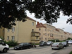
The Raxstraße located in the 10th Viennese district of favorites in the district part Inzersdorf City . It was named in 1932 after the Rax , a popular excursion mountain for the Viennese.
Location and characteristics
.jpg)
Raxstrasse is part of the former B225 federal road , an important east-west connection in the south of Vienna. Raxstrasse begins with its house numbers on Laxenburger Strasse in the east and extends on the ridge of the Wienerberg to Triester Strasse in the west. It is continued in the east by Grenzackerstraße, which extends to the Südosttangente city motorway , and in the west by Wienerbergstraße, which extends to Breitenfurter Straße (a southern exit of the city) . The thoroughfare with a large volume of traffic is broadly developed for car traffic and is partially flanked by side lanes.
Public transport on Raxstraße are bus lines 15A and 65A. Tram line 1 has its southern terminus in Windtenstrasse at Raxstrasse, the southern terminus of tram line O at Neilreichgasse is called Raxstrasse / Rudolfshügelgasse. The tram line 67 crosses Raxstraße at Neilreichgasse, the bus lines 66A and 67A cross them at Laxenburger Straße.
The construction with residential buildings, which began in the 1920s, is usually not located directly on the street, but offset behind the building line by side lanes or green areas. In addition to apartment blocks, the Raxstrasse company garage of Wiener Linien for city buses and an adjoining sports facility are located on Laxenburger Strasse . The area of the historic Wienerberg water reservoir is located near Triester Straße, at the western end of the street .
Building
The odd house numbers are on the southern side of the road, the even house numbers on the north. For information such as No. 7-27 (the usual spelling in Vienna), only those numbers that are also odd, on the same side of the street, are meant between the listed numbers, i.e. 9, 11, 13, etc. Analogously to No. 6–8 is the No. 7, contrary to the spelling, not included!
No. 1: Company garage in Raxstrasse
The Wiener Linien company garage at Sahulkastraße 2 between Raxstraße and Sahulkastraße is the home garage for vehicles on the urban bus routes 13A, 14A, 15A, 59A, 65A, 66A, 69A, 74A and several night bus routes.
No. 6–8: Urban residential complex
The urban residential complex was built by Karl Schwarz from 1952 to 1953. It consists of 15 stairs with 278 apartments between Leebgasse , Migerkastraße, Rudolfshügelgasse and Raxstraße. The five-storey complex, which is otherwise designed as a block edge construction, opens wide towards Raxstrasse and is connected to a neighboring building by a street overbuilding in Migerkastrasse. Around the large, garden-like courtyard there are eight terracotta reliefs by Michael Powolny with depictions of animals and children.


No. 7-19A: Johann Mithlinger settlement
→ Main article: Johann Mithlinger settlement
1929–1931 the very large urban residential complex Johann-Mithlinger-Siedlung , originally called Rasenstadt , was built by the Vienna City Building Authority according to plans by Karl Schmalhofer . Since the zone south of Raxstraße had not been built with apartment blocks before, the architect chose a design based on the idea of the garden city with 24 free-standing houses, accentuated by pointed bay windows and corner loggias, which are grouped like a grid and between which there are generous green areas. The facility extends between Neilreichgasse , Sahulkastraße, August-Forel-Gasse and Raxstraße. Fritz-Pregl-Gasse and Ernst-Ludwig-Gasse run within the complex. Between 1939 and 1940, 16 fairy-tale pictures made of painted ceramics or terracotta reliefs were attached to the outside of the settlement, created by several artists such as Jan Hendrik Foitik, Karl Perl or André Roder in the tradition of the Wiener Werkstätte. After the war, the turf town was named after the executed resistance fighter Johann Mithlinger , to whom a memorial plaque was dedicated.
Johann Mithlinger settlement

Mother Hulda
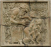
Rübezahl
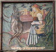
Little Red Riding Hood
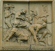
The seven Swabians
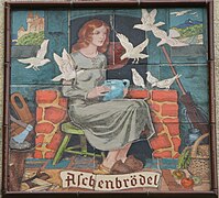
Cinderella
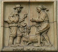
Hans in hapiness
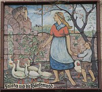
Falada and the goose girl

Memorial plaque Johann Mithlinger


No. 10: Jean-Jaurès-Hof
→ Main article: Jean-Jaurès-Hof
The Jean-Jaurès-Hof was built in 1925–1926 by Walter Broßmann and Alfred Keller . The residential complex between Neilreichgasse , Raxstraße, Rudolfshügelgasse and Migerkastraße was built free-standing on a previously undeveloped area near allotment gardens . There are 389 apartments in it. The complex, designed as a four-sided block edge construction, is divided in the middle by a transverse wing and extends around two equally large inner courtyards, from which the staircases are accessible. A day care center is housed in one of the courtyards. Originally, in addition to the after-school care center, the residents also had two shops, an inn and a central laundry room.
The Jean-Jaurès-Hof has a homely, homely character due to its high-quality designed details, as well as its varied shapes, such as protruding pointed oriels and risalits , multi-tiered roof landscapes and the beautifully planted inner courtyards. The two portals on Neilreichgasse and Rudolfshügelgasse are monumentally designed. There are round arched passages with coffered barrel vaults . Furthermore, there are wrought iron grids and canopies in Art Nouveau forms within the complex. Between 1991 and 1995 the Jean-Jaurès-Hof was renovated and the playground was repaired.


No. 21, 23, 25–27: Urban housing complex
In the years 1931 to 1933, the residential complex was built by the Vienna City Planning Department according to plans by Johann Flieger. It is closely linked to the neighboring Johann Mithlinger estate and consists of six detached semi-detached houses with a total of 260 apartments within green spaces. The facility is located between Raxstrasse, August-Forel-Strasse and Stefan-Fadinger-Platz, where the Carmelite Church (see below) is visible from afar.
No. 22: Urban housing complex
The municipal housing complex between Fernkorngasse and Georg-Wilhelm-Pabst-Gasse was built in 1963–1965 by Max Philippitsch and Alfred Podgorschek. It consists of four free-standing parallel block buildings with a total of 135 apartments. The simple buildings are only structured by colored balconies on the south sides. Up until the 1950s, there were small craft businesses in wooden barracks on the site, which were used by the Reich Labor Service during the Nazi era .
Church on Stefan-Fadinger-Platz
→ Main article: Parish church Maria vom Berge Karmel (Vienna)
Between house numbers 27 and 27A, on the south side of Raxstrasse, the northernmost part of Stefan-Fadinger-Platz connects, one block further south, four times as wide, from the Carmelite Church of Maria vom Berge Karmel ("Our Lady of the Mountains Karmel") is controlled. The reinforced concrete church on the top of the Wienerberg , built by Hans Prutscher between 1928 and 1942 , is clearly visible from Raxstrasse and can be seen for miles from the south on the drive to Vienna. The listed church was sold to the Syrian Orthodox Church of Antioch in 2014 and is now dedicated to St. Dedicated to Ephrem .
In a bomb hit in 1945, the church, into which people had fled when the bomb was alarmed, and some houses were destroyed. A memorial stone on the side facing Stefan-Fadinger-Platz commemorates this devastating event.


_-_Syrisch-Orthodoxe_Kirche_mit_ehemaligem_Klostergeb%C3%A4ude.JPG)
_-_Syrisch-Orthodoxe_Kirche.JPG)


No. 27A: Urban housing complex
The urban residential complex was built between 1961 and 1963 by Paul Detre, Otto Gruen, Hans Muttoné and Fritz Novotny. The simple four-storey block building comprises 72 apartments. There is a children's playground next to the building.
No. 29–111: Settlement Am Wasserturm
1923–1924, the extensive settlement was built as part of the home construction aid of the municipality of Vienna by GESIBA according to plans by Franz Schacherl and Franz Schuster . These are one- and two-story family houses with front and house gardens, some of which are also grouped in rows or blocks. The settlement is located between Raxstraße, Stefan-Fadinger-Platz, Weitmosergasse and Altdorferstraße. The streets within the settlement are named after leaders from the time of the peasant wars. In the center is the expanded Weigandhof.


No. 38: Urban residential complex
1961–1963 the urban residential complex was built by Paul Ehrenzweig, Rudolf Jarosch, Hannes Lintl, Libuse Partyka and Eugenie Pippal-Kottnig , which is connected to the neighboring complex at Gussriegelstrasse 42–50. The four-storey block building comprises 35 apartments in the middle of a green area. There are mosaic strips on the portals.
No. 50: Wienerberg water tank
→ Main article: Wienerberg water reservoir
Across from the settlement at the water tower, the extensive area of the Wienerberg water reservoir extends between Windtenstrasse and Triester Strasse . The terrain, which was previously closed to the public, has been redesigned on the surface into an adventure world for children and a recreation area since 2011.

Administration building and water tower

Administrative building

Water tower

Intake structure

Water school
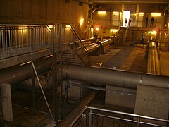
Water tank inside

Water world

Wienerberg substation


No. 113: Urban residential complex
Robert Hartinger and Silvio Mohr built the urban residential complex between 1929 and 1932 . It consists of a block edge development between Raxstraße, Triester Straße and Altdorferstraße, which is open on the side to Altdorferstraße and offers access to the green inner courtyard. This access is particularly emphasized by loggias, exposed brick balustrades and majolica decor. On the side facing Triester Straße there is a large colored tile picture depicting the legend of the spinner on the cross from 1938. The component facing Raxstraße, which was last built, is more objective and simple than the others. During the renovation, which took place from 2007 to 2009, the color of the facade was changed.
literature
- Herbert Tschulk: Viennese district culture guide favorites . Jugend & Volk, Vienna 1985, ISBN 3-224-10612-3
- Bundesdenkmalamt (Ed.): Dehio-Handbuch Wien. X. to XIX. and XXI. to XXIII. District . Anton Schroll, Vienna 1996, ISBN 3-7031-0693-X
Web links
Coordinates: 48 ° 9 '59.2 " N , 16 ° 21' 32.9" E