
Trieste Street
| Trieste Street | |
|---|---|
|
|
|
 |
|
| Basic data | |
| place | Vienna |
| District | 10th district , 23rd district |
| Created | in Roman times |
| Hist. Names | Neustädter Poststrasse |
| Connecting roads | Wiedner Hauptstrasse |
| Cross streets | 10th district: Gudrunstraße , Quellenstraße , Buchengasse , Rotenhofgasse, Kundratstraße , Davidgasse , Inzersdorfer Straße, Angeligasse , Hardtmuthgasse, Troststraße , Quaringasse, Franz-Schuh-Gasse, Windtenstraße, Raxstraße , Wienerbergstraße , Altdorferstraße, Hertha-Firnberg-Straße, Computerstraße, 23 District and a .: Anton-Baumgartner-Strasse, Purkytgasse, Sterngasse, Erlaaer Strasse, Ketzergasse |
| Buildings | Matzleinsdorf Evangelical Cemetery , George Washington Hof , spinner on the cross |
| use | |
| User groups | Pedestrians , bicycle traffic , car traffic , bus route 65A , local railway Vienna – Baden , regional bus routes |
| Technical specifications | |
| Street length | approx. 6900 m |
The Triesterstraße is, historically, the most important road of Vienna to the south. It is part of the former B17 federal road . Since the 1960s, its function as a trunk road has been largely taken over by the A2 southern motorway , to which it now serves as a feeder. The very high traffic frequency on Triester Straße to this day is based on the expansion of the bacon belt south of Vienna that began in the 1960s (see e.g. Südstadt ).
history
Where Triester Straße is located today, an important route from Vienna to the south had been running since Roman times , with the route roughly leading from today's Kärntner Straße via today's Wiedner Hauptstraße to Triester Straße. The destination of the Romans was Scarabantia, today's Sopron (Ödenburg). A Roman road section was excavated in 1914 at the confluence of Kundratstrasse and Triester Strasse. Roman milestones have been found in the area of Inzersdorf.

In the Middle Ages, Triester Straße was a long-distance trade route that led via Semmering and Styria to Carinthia , Friuli and Veneto . From the height of the Wienerberg, the departing was offered the last view of the city of Vienna. The late Gothic statue Spinner on the Cross was erected here in the 15th century , around which a legend from the time of the Crusaders is entwined. An execution site was located here until 1747 , which was again used as such from 1805 to 1868. The Teufelsmühle , which is also the scene of an old legend, was located on Triester Straße at today's city limits in Siebenhirten .
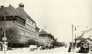
In 1883 Triester Straße was given its current name, which marks the end of the long road connection to the south, the then imperial-Austrian port city of Trieste . The Reichsstrasse, d. H. Street preserved by the state , until then was mainly known as Neustädter Poststraße , which was especially popular under Emperor Karl VI. It had been expanded at the beginning of the 18th century. There were brick factories on the grounds of the Wienerberg. It was not until the end of the 19th century that the first building was built on the west side on the former Steinbüchel grounds with the establishment of the Franz Josef Hospital. At the height of the Wienerberg, the water tower and a lift of the first Viennese spring water pipeline were built. In 1902, trams began operating on Triester Straße from Matzleinsdorfer Platz ( Gudrunstraße ) to Troststraße .
In the inter-war period, several urban residential complexes in Red Vienna were built , especially the spacious George Washington Court complex . Since 1907 the tram line 65 ran on Triester Straße to Troststraße , since 1924 the line 165 ran to the border in Inzersdorf (see section on public transport).
In 1934, the paved bridle paths running on both sides of the road were removed and the road was widened for car traffic up to the Spinnerin am Kreuz. After the Second World War, it was expanded again, provided with a median that separated the lanes, and tram line 65 was relocated to Knöllgasse, which ran parallel, while line 165 was discontinued at all.
Course and characteristics
.jpg)
Triester Straße runs from Matzleinsdorfer Platz on Margaretengürtel (district border 5/10) to the south, first to the height of Wienerberg and from there down to the crossing Liesingbach , where the street leaves the 10th Viennese district, Favoriten (until 1938 city limits) and in the 23rd district, Liesing , through the districts of Inzersdorf , Erlaa and Siebenhirten to the city limits of Vienna, which have been in effect since 1954. In the Lower Austrian communities on the B17 in the south, the name Triester Straße is also often used. (As a federal road, the road to the Italian border was called that until 1971.)

As the main thoroughfare, which in Favoriten has three lanes in each direction of travel, Triester Straße is characterized by enormous car traffic and poor quality of life for residents. Accordingly, residential buildings can only be found at the beginning of the street on the east side up to the height of Wienerberg (most of them come from the time before the automobile era) and then again in remnants in Inzersdorf and Siebenhirten, where the original single-storey residential buildings there are increasingly being displaced by companies and commercial operations become. The west side of the street in the 10th district is initially also lined with businesses, followed by the site of the Franz Josef Hospital . At the height of the Wienerberg is the symbol of the spinner on the cross and the extensive residential complex of the George Washington Hof is located . After that, the skyscrapers in Wienerberg City form a skyline in the south of Vienna that can be seen from afar. Down the slope of the Wienerberg, the Triester Straße runs through the unspoilt Wienerberg recreation area, at the foot of which the Triester Straße is crossed by a bridge with the railway tracks of the Pottendorfer line and the underpassed Liesingbach. Then there is the connection between Triester Straße and the Süd Autobahn or the Südosttangente . From here to the city limits, the course is characterized by the village houses of the former local communities Inzersdorf and Siebenhirten.
The Martin-Luther-King-Park is on the corner of Triester Strasse and Kundratstrasse. On the southern slope of the Wienerberg, the street crosses the Wienerberg recreation area, which is important for the south of Vienna and which was created at the end of the 20th century on the rather unseen area of the former brick factories. In Inzersdorf, along the Liesingbach, extends the Draschepark , a former castle park that now houses cycle paths and other leisure facilities.
Public transportation

In the section of the street closest to the city center, as far as Troststraße, the city tram has been running since 1902 , since 1907 as line 65. In order to create more space for individual traffic on Triester Straße, it was started in 1967 via the first parallel street eastwards, Knöllgasse, and has been running since 2008 as line 1 from Raxstrasse , Stefan-Fadinger-Platz, through Knöllgasse, and later over part of Ringstrasse and Franz-Josefs-Kai to Prater , Hauptallee . On Friday and Saturday nights, the part of Triester Straße closest to the center is served by the N62 night bus line, also operated by Wiener Linien .
From 1924 to 1962 the tram line 165, which runs on the southern slope of the Wienerberg directly on Triester Straße to Inzersdorf, was an extension of the 65. It was then switched to bus service (line 65A) and now runs the route from Reumannplatz (U1) to Wienerberg City or once an hour, sometimes on Triester Straße, to Zetschegasse in Inzersdorf.
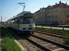
In the southernmost section of Triester Straße in Vienna, where mostly only the houses on the western edge of the road belong to Vienna, the street itself and its eastern neighbors to Lower Austria, the local railway Vienna – Baden , the so-called Badner Bahn , accompanies the street directly parallel. The stops at Neuerlaa, Schönbrunner Allee and Vösendorf-Siebenhirten (opposite the Teufelsmühle , Triester Straße 342) are available to residents . The Viennese tram tariff applies to this section of the Badner Bahn line; four to eight trains per hour are generally run towards the city center.
The Badner Bahn also runs right next to the road in several communities south of Vienna; the tariff of the Verkehrsverbund Ost-Region (VOR) applies . This tariff also applies to the regional bus routes to Lower Austria and Burgenland , some of which travel the full length of Triester Straße.
Notable addresses
From Matzleinsdorfer Platz to Wienerbergstrasse
The station Wien Matzleinsdorfer Platz on the Südbahn in an elevated position ( S-Bahn main line ) and the tram station in a lower position under the Margaretengürtel form the “gate” to Triester Straße, from which Gudrunstraße branches off to the east into the center of Favoriten . The Triester Straße climbs from here to the ridge of the Wienerberg .
No. 1: Matzleinsdorf Evangelical Cemetery
At the beginning of Triester Straße is the Matzleinsdorf Evangelical Cemetery with the striking Christ Church. The cemetery was inaugurated in 1858 and the church was built in the historicist style from 1858 to 1860 according to plans by Theophil Hansen . It was modeled on a Greek church. It forms a unit with the administrator's house and the gravedigger's house, all of which were built using exposed brick.
The graves of numerous important personalities of Protestant Vienna are located in the cemetery. Among other things, the graves of the writers Friedrich Hebbel , Heinrich Laube and Ada Christen , the philosopher Otto Weininger , the actors Adele Sandrock , Zerline Gabillon and Heinrich Anschütz , the Imperial and Royal Finance Minister Karl Ludwig von Bruck , the painter Hugo Darnaut , the Austromarxist social philosopher Max are located here Adler , the industrialist Rudolf von Arthaber and the Viennese original Baron Karl .

Christ Church

Parish office

Hofmeier's grave

Grave of Lorenz von Stein

Friedrich Hebbel grave
Grave of Ada Christians

Grave Adele Sandrock

Grave of Wilhelm Hellwag

Grave Max Winter
.jpg)


Corner of Kundratstrasse: Martin-Luther-King-Park
See Kundratstrasse .


No. 33: former bank building
The former bank building at Triester Straße 33 was built from 1963 to 1966 according to plans by the architect Carl Appel and from 2006 to 2015 was owned by a large Viennese digital printing company (digiDruck). In 2016, Michael Gitzi's property was sold to Caritas.
No. 46–50: Favoriten Clinic, until 2020 Kaiser-Franz-Josef-Spital
Here the area of the Kaiser-Franz-Josef-Spital , which was built in 1887, connects to Triester Straße, which has been operating as Klinik Favoriten since 2020 . Entrance and access today is from Kundratstrasse.
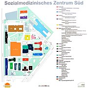
Orientation plan

Headquarters
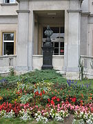
Emperor Franz Josef bust

Emperor Franz Josef bust in detail

Rear of the management building
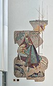
"Good Samaritan" mosaic

Entrance pavilion
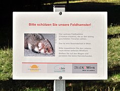
European hamsters live on the hospital grounds

Hospital chapel


_-_Kaiser-Franz-Josef-Spital,_Kapelle_(1).JPG)
No. 51–53: Community housing
The relatively small urban residential complex opposite the Kaiser-Franz-Josef-Spital was built in 1929 according to plans by the architect Johann Franz Würzl . It comprises 37 apartments. The facade on Triester Straße is accentuated by bulky, symmetrical bay windows in the style of Cubism. There is a green inner courtyard at the rear of the building.
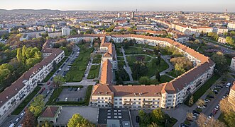
No. 52–56: George Washington Hof
At the height of the Wienerberg, west of Triester Straße, with its narrow side facing it, is the spacious George-Washington-Hof , an urban residential complex from the years 1927–1930 designed by the architects Karl Krist and Robert Oerley . The complex, which extends in five wide courtyards along Wienerbergstrasse to the west, opens onto Triester Strasse with a street courtyard designed by Karl Krist. On the street itself is the former mother advice center, which has a ceramic sculpture of mother with children and window frames by Josef Riedl in relief.
Birkenhof from the air

Beginning of Unter-Meidlinger Straße

George Washington Courtyard
George Washington

Mother with children of Josef Riedl

former mother counseling

Passage Birkenhof / Fliederhof

Fliederhof


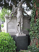
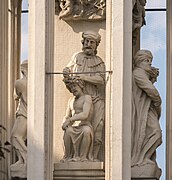
In front of No. 52: Spinner on the cross
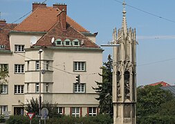
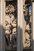
In front of No. 52 is the probably best-known and also the oldest building in Favoriten, the late Gothic statue of the spinner on the cross . A square, 16-meter-high column rises on a stepped foundation with groups of stone figures on each side. It is about the flagellation of Christ, his crowning of thorns, an Ecce Homo depiction and Christ on the cross between Mary and John. Above it rise pinnacles, flying buttresses and pointed turrets with stone rosettes and gargoyles, which are finally crowned by a stone cross.
The predecessor of today's column was built in 1379 by cathedral builder Michael Knab . However, it was almost completely destroyed by the Hungarians under Johann Hunyadi in 1446 . That is why the City of Vienna commissioned the cathedral builder Hans Puchsbaum in 1451/52 with a new statue. After several restorations, the valuable sculptures on the busy street could no longer be exposed to the damage caused by car exhaust fumes, and the originals were handed over to the Favoriten district museum , while copies were placed on Triester Straße.
Various legends are linked to the building, the most famous of which relates to the wife of a crusader, who looked here from the top of the Wienerberg to the south for her husband returning home and spun while waiting.
Already in 1296 there was a report of a stainern kreucz ob meurling , in 1650 people spoke of the Kreutz am Wiennerperg , in 1709 of the statues on the Wienner-Berg, commonly known as the Creutz-Spinnerin or Spinnerin-Creutz , until 1804 the current name is occupied. For many years (until 1868) one of the two execution sites on Wienerberg was located here .

around 1840

Photo from 1933

Windtenstrasse
Weirdo with the George Washington court


East Side
South side
West side

North side

Tile picture of the legend around 1938, Triester Straße 85


_IMG_9614.jpg)


No. 57–65: Viktor-Adler-Hof

In 1923, the Viktor-Adler-Hof urban residential complex with 111 apartments was built according to plans by the architect Engelbert Mang . The complex is strictly symmetrical and has a higher, gable-crowned central projection, wide round loggias and groups of balconies. From 1923–1928, the future mayor of Vienna Felix Slavik lived here as a boy. At the time of construction, the Viktor-Adler-Hof towered over all other buildings on the left side of Triester Straße and dominated the area. At the corner of the complex facing the city center, Troststrasse with house no. 125 joins Triester Strasse. The tram originally ran this far.
No. 75–77: Community housing
This urban residential complex was built in 1929 according to plans by Karl Fischl . The corner construction facing Windtenstrasse is sloping and is accentuated by two-storey pointed core and pointed gables. The complex comprises 45 apartments. It is the only known building by the architect from the interwar period.
No. 83: Water tower and lifts Favoriten
At the height of the Wienerberg, opposite the George-Washington-Hof, to the east of Triester Straße is the area of the water tower and the Favoriten lift between Windtenstraße and Raxstraße . The Wienerberg water reservoir of the 1st Vienna High Spring Water Pipeline extends to Triester Straße, where there is a water reservoir from 1873 with mighty groin vaults on massive pillars. On the street you can see the inlet structure, which shows a representative house facade in neo-renaissance forms.

Administration building and water tower

Administrative building

Water tower

Intake structure

Water school
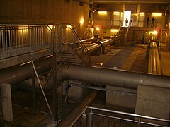
Water tank inside

Water world

Wienerberg substation


No. 85: Municipal housing

This urban residential complex with 153 apartments dates from 1932/1933 and was built according to plans by the architects Silvio Mohr and Robert Hartinger . It is a block construction around a courtyard that is open to Altdorferstrasse and has an economical majolica decor. On the side facing Triester Straße there is a large tile picture from 1938 depicting the legend of the spinner on the cross. The facility was renovated in 2008/2009.
From Wienerbergstrasse to Liesingtal
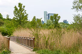
From the height of the Wienerberg, where the Wienerberg City with its striking skyscrapers is located a short distance west of Triester Strasse , the street descends into the Vienna Basin and reaches it at Liesingbach , which the street crosses at the Badner Bahn station Inzersdorf .

No. 64–66: Philips House
On the southern edge of the Wienerberg rises, visible from afar, the so-called Philipshaus, an office building of the Philips company , which was built 1962–1964 and 1969/1970 according to plans by the architect Karl Schwanzer . The building is clamped in a striking form between four columns. Until the construction of the neighboring Wienerberg City with its even higher towers, this building was the dominant feature of the southern Wienerberg. In June 2016 it was announced that the building sold by Philips will be converted into 135 luxury suites.
No. 87: Liewers car dealership
The architect Rudolf Vorderegger built this high-quality building between 1955 and 1957, some of which still have original furnishings.
Wienerberg recreation area
The hardly built-up southern slope of Wienerberg functions as a local recreation area on both sides of Triester Straße. The former Gstättn (Viennese for an overgrown garden or square) was expanded using the old brick ponds . There are ponds and natural areas on the east side, while a golf course, sports fields and budo center are on the west side.

Southern Wienerberg area, Triester Straße in the middle

Wienerberg City and the former Philips house
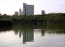
Wienerberg pond
Wienerbergteich and Wienerberg-City

Recreation area

Wienerbergteich towards the east


No. 114: Forest Office Directorate
The building at the southern foot of the Wienerberg was built in 1912/1913 as an elementary school right on what was then the southern city limits. It is a free-standing brick building in late secessionist forms. From 1924 to 1962 the southern terminus of the 165 tram was in front of the house (see section on public transport).
The side of the building facing away from Triester Straße served as the backdrop for the Austrian television series MA 2412 . Since March 2013, the house has been the seat of Municipal Department 49, Forestry Office and Agricultural Company of the City of Vienna .
former elementary school with the terminus of tram line 165 (1930)


Façade Triester Straße

Rear


Railway bridge
On the bridge, the Pottendorfer line from Vienna Meidling station and the Donauländebahn from Meidling and Altmannsdorf to the Donauuferbahn ( Albern , Handelskai ) cross the street. Since 1954, the border between the 10th and 23rd district has been running on the southern edge of the track. The southern city limits were located here until 1938; until 1954, the adjoining district to the south was number 25.
No. 167: former Line Office

The former line office was built in 1891 just south of the then new city limits, today the district boundary 10/23 , as a free-standing, three-storey building accented by gables under crooked roofs. The construction became necessary when the southern slope of the Wienerberg, which had belonged to Inzersdorf as Rudolfshügel, was incorporated into Vienna from 1890 to 1892. The line office was used to collect the consumption tax at the city limits.
.jpg)
Bridge of the southeast bypass
In the 1970s, the so-called Südosttangente was built, which, as the A23 motorway, links Altmannsdorfer Straße, Triester Straße, the southern motorway starting here and other motorways in south-east Vienna. The tangent leads over the Prater Bridge to the left bank of the Danube and is known as the busiest section of the autobahn in Austria. It crosses Triester Straße north and south of the Liesingbach on two bridges.
From the Liesingtal to Neuerlaa
The third of four Viennese sections of Triester Straße, mostly to the west of the street, is accompanied by the Badner Bahn, which runs right next to the street or in the first parallel street. In the shadow of a motorway bridge, it has the Inzersdorf Personenbahnhof stop, and the Neuerlaa stop in the southern part of the section. The area came to Vienna in 1938 and is built up in a mixture of industrial buildings, warehouses, single-family houses and residential complexes. In the north of the section, Sterngasse leads to the Inzersdorf junction of the Südosttangente , in the southern part the Südautobahn runs three blocks east of Triester Straße parallel to it through the Inzersdorf industrial area and southwards.
No. 199: former school building
The building at the corner of Triester Straße / Sterngasse was built in 1887/1888 by the Inzersdorf community as a school building. Since the population had risen sharply, an additional school building was needed for the new districts of Neustift (along Triester Straße) and Neusteinhof . The area was incorporated into Greater Vienna in 1938 .
From Neuerlaa to Ketzergasse
In Neuerlaa, the Altmannsdorfer Strasse (Vienna) / Schönbrunner Allee (Vösendorf) crosses Triester Strasse at an acute angle. From here to the south, Triester Straße and the area east of it belong to Lower Austria , the buildings on the western edge of the street belong to Vienna. The fourth, southernmost section of the street in Vienna is built in a similar way to the third. The Badner Bahn accompanies Triester Straße here too, right next to the eastern edge of the road; it has the stops Schönbrunner Allee and, opposite the Ketzergasse, Vösendorf-Siebenhirten.
No. 342: Devil's Mill

The now heavily neglected and functionless building at a busy intersection is on the corner of Ketzergasse on Petersbach . The Teufelsmühle is mentioned for the first time in 1590/1591, but it is almost certainly older. Your name is likely derived from that of an owner or tenant named Teufel. Since the 18th century there was an inn in place of the mill, which served as a resting station for the country carriages to Baden near Vienna . During the pre-March period it was known for its sausages. A legend known since the 18th century is associated with the Teufelsmühle. Karl Friedrich Hensler wrote a play about the Teufelsmühle, which was staged with great success in the Leopoldstadt Theater .
In 1903 the house burned down and was replaced by the current building. In 1938 the area came to Vienna. The function as a rest station has long since become obsolete. The city and state border with Lower Austria has been running directly next to the building to the east and south since 1954 .
South of Vienna
The local street name Triester Straße is also often used in the Lower Austrian communities on the B17 in the south . (As a federal road, the road to the Italian border was called that until 1971.) Here, too, the Badner Bahn mostly runs right next to the road, but changes the side of the road several times.
Notable addresses are here:
- the animal shelter of the Vienna Animal Welfare Association in Vösendorf
- the Shopping City Süd (SCS) in Vösendorf
- the prefabricated house exhibition " Blue Lagoon " in Vösendorf
- the federal sports and leisure center Südstadt in Maria Enzersdorf
- the Südstadt Stadium in Maria Enzersdorf
- die Südstadt , prototype for the development of the bacon belt south of Vienna

Badner Bahn station Vösendorf

Pyramid Vösendorf
Badner Bahn near Vösendorf

Triester Straße south of Vienna near the Shopping City Süd

Traffic at the Shopping City Süd

at the Shopping City Süd
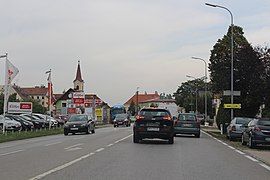
Triester Straße in Wiener Neudorf


._%D0%90%D0%B2%D1%81%D1%82%D1%80%D0%B8%D1%8F._-_panoramio.jpg)
literature
- Herbert Tschulk: Viennese district culture guide favorites . Youth & People: Vienna, 1985
- Felix Czeike : Historisches Lexikon Wien , Vol. 5. Kremayr & Scheriau: Wien, 1997
- Dehio Handbook Vienna. X. to XIX. and XXI. to XXIII. District . Verlag Anton Schroll: Wien, 1996
- Walter Krobot, Josef Otto Slezak , Hans Sternhart: Tram in Vienna - the day before yesterday and the day after tomorrow , Verlag Josef Otto Slezak, Vienna 1972, ISBN 3-900134-00-6 , p. 327 f.
- Beppo Beyerl : The street with seven names: From Vienna to Trieste . Löcker, Vienna 2013, ISBN 978-3-85409-650-4
- Beppo Beyerl: The Triester Straße: A history of the traffic route from Vienna to Trieste in pictures . Edition Winkler-Hermaden, Schleinbach 2015, ISBN 978-3950373998
Individual evidence
- ↑ News from June 14, 2016 on the ORF website
- ↑ Ute Woltron : The old car dealership on Wienerberg , nextroom.at , December 7, 2018
- ^ Exhibition website
- ^ Website of the center
Web links
Coordinates: 48 ° 9 ′ 48 ″ N , 16 ° 20 ′ 45.2 ″ E