Prater Bridge
Coordinates: 48 ° 12 ′ 26 ″ N , 16 ° 26 ′ 11 ″ E
|
|
||
|---|---|---|
| The Prater Bridge over the Danube | ||
| use | Motorway bridge Südosttangente | |
| Convicted |
Danube New Danube |
|
| Subjugated | Danube bank motorway | |
| place | Vienna , districts Leopoldstadt and Donaustadt | |
| vehicles per day | 200,000 | |
| start of building | 1967 | |
| completion | 1970 | |
| opening | December 22, 1970 | |
| location | ||
|
|
||
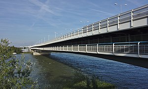
The Praterbrücke is an eight-lane motorway bridge over the Danube in Vienna and connects the 2nd ( Leopoldstadt ) and the 22nd district of Vienna ( Donaustadt ) at river kilometer 1,925.8 . It is a section of the southeast tangent (A 23) and consists of a steel structure spanning the Danube and prestressed concrete structures crossing the adjacent Danube Island and New Danube . The bridge is used by around 200,000 vehicles every day; it is the busiest bridge in Austria.
history
The Prater Bridge was built from 1967 to 1970 with six lanes (three in each direction). During assembly, the rapid temperature changes at night caused such high tensions that the steel structure buckled in two places on November 5, 1969 and the construction site, including the traffic routes underneath (road, rail, river) had to be closed due to the risk of collapse. The load-bearing capacity was restored by means of welded-in girders that bridge both kinks, so that the Prater Bridge could be opened to traffic on December 22, 1970. However, the effects of the kinks remained visible through a slight depression in the lanes on the bridge. After this incident, the bridge was briefly called the “Knickbrücke” in everyday life.
Due to the construction of the Freudenau power plant and the associated damming of the Danube, the bridge had to be raised by 1.8 meters in 1996/1997. During the construction work, traffic was diverted to the south via the specially built Donaustadtbrücke .
In addition, an additional lane in each direction and new footpaths and cycle paths were built. These are protected from rain under the carriageway: the northern cycle path is (orographically in the left section over the New Danube) on its own suspension bridge structure in the middle of the bridge's longitudinal axis, so lowered that relatively flat connections to the banks are possible. The southern section (over the Danube) is on the upstream side - due to shipping - significantly higher and next to the box profile of the bridge, covered by the cantilevered edge of the road. Its connection to the left bank of the Danube (to the Danube Island) is via a ramp with several turns, which is a (braking) technical challenge, especially downhill, due to the relatively steep incline, tight curve radius and about 10 m difference in height for heavy bicycle teams and inline skaters.
After the construction work was completed, the Donaustadtbrücke was used for the 84A bus line, which was able to cross the Danube in this way without being hindered by the motorway traffic on the Praterbrücke and possible traffic jams. After the Donaustadtbrücke became an underground bridge in 2006, the 84A bus again ran over the Praterbrücke. On October 2, 2010, as part of the extension of the U2 underground line, the bus line was discontinued, and since then there has been no more public transport across the Prater Bridge.
In the spring of 2015, the general renovation of the Prater Bridge began, which was completed in 2017. The lowering of the carriageway in the southern part, which has existed since the opening, remained in place.
Individual evidence
- ↑ A 23 Südosttangente Wien General renovation of the Prater Bridge ( memento of the original from October 3, 2016 in the Internet Archive ) Info: The archive link has been inserted automatically and has not yet been checked. Please check the original and archive link according to the instructions and then remove this notice. (accessed May 28, 2017).
- ↑ Short article with picture in: Eisenbahn. ISSN 0013-2756 ZDB -ID 162227-4 , year 1970, issue 1, p. 5.
- ↑ a b Image source for the Knickbrücke ( memento of the original dated May 11, 2017 in the Internet Archive ) Info: The archive link has been inserted automatically and has not yet been checked. Please check the original and archive link according to the instructions and then remove this notice. From: The motorway network in Austria. 30 years of ASFINAG. January 2012. p. 151. (accessed May 28, 2017).
- ↑ Details on the bridge elevation (accessed May 28, 2017).
- ↑ Renovation of the Vienna Prater Bridge postponed to 2015 derstandard.at from September 3, 2014


