Dhekelia port
| Dhekelia port | |||
|---|---|---|---|
| Data | |||
| UN / LOCODE | CY DHK | ||
| operator | CPA.GOV.CY and others | ||
| opening | 1957 | ||
| Port type | seaport | ||
| Goods handled | 517,000 t of oil products | ||
| website | Dhekelia port | ||
| Geographic information | |||
| place | Dhekelia | ||
| republic | Republic of Cyprus | ||
| Country | Republic of Cyprus | ||
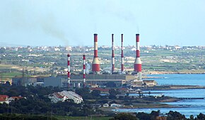
| Dhekelia Power Station, view from the west (2013) | |||
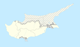
| Coordinates | 34 ° 58 '44 " N , 33 ° 43' 59" E | ||
|
|||
The port of Dhekelia ( Greek Λιμάνι Δεκέλεια ) is a seaport in the Larnaka district and is now the second largest oil port in the Republic of Cyprus .
geography
The port facilities of Dhekelia are located at the Dhekelia Power Station , about 15 km east of Larnaka in Larnaca Bay on the Mediterranean Sea . Immediately to the north is the British military facility Dhekelia Base .
There are several parts of the port specially adapted for the respective purposes: Map with all coordinates: OSM | WikiMap![]()
| Port part | Port type | location | Quay length | depth | Equipment and use |
|---|---|---|---|---|---|
| Ormedia | Harbor basin | ⊙ | 70 m, quay | k. A. | Fishing harbor, jetty, slipway , 20 berths for small vehicles , dry berths , catering |
| Oil port | Roadstead | ⊙ | no | k. A. | Pipeline , buoys |
| Marina | Marina | ⊙ | 90 m quay | 1.5-4 m | 15 berths for small vehicles, pastoral care |
| West Pier | Pier | ⊙ | 150 × 12 m | k. A. | massive landing stage, ro-ro ramp for amphibious vehicles, commercial and operational buildings, harbor warden berth |
history
The area has been under British influence since the 1880s and was annexed during World War I in 1914. The turmoil of the Second World War passed the sleepy fishing village almost without a trace. In 1957, the Dhekelia Power Station was built there, a power plant that is supplied with heavy fuel oil by sea and provides almost half of Cyprus’s electricity needs. In 1960 Cyprus became largely independent of the British crown and the facilities have been continuously expanded and renewed since then.
The port has belonged to the European Union since the Republic of Cyprus joined in 2004 , but is still used by British units.
Description and infrastructure
The easternmost part of the port is the fishing port at Ormedia with an approximately 0.7 hectare large harbor basin protected by a 120 m long breakwater . There is a slipway and catering there.
Oil tankers lie in the roadstead directly south of the power plant and unload cargo via a pipeline . Large commercial shipping can also bunker fuel there.
Small vehicles and yachts can be found in the marina in Dhekelia Bay, one kilometer further west . They have their own supply and disposal facilities and the Greek Orthodox Church on a peninsula provides pastoral care for the seafarers. A breakwater with a length of 80 m protects this part of the harbor, which is mainly used for recreational shipping. This part of the port is completely insignificant for commercial large-scale shipping.
To the west of this is the 150 × 12 m massive pier , which was built as a ro-ro ramp for military purposes , as well as the dock of the harbor master's office. Ferry and passenger shipping only use the port in exceptional cases.

