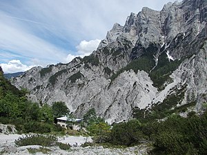
Haindlkarhütte
| New Haindlkarhütte ÖAV hut category I |
||
|---|---|---|
|
The hut is located under the climbing walls of the Haindlkar in the Hochtor group, from the left: Planspitze , Peternschartenköpf, Rosskuppe and Dachl. |
||
| location | in the great Haindlkar; Styria , Austria ; Valley location: Gstatterboden | |
| Mountain range | Ennstal Alps - Gesäuse | |
| Regions | Gesäuse National Park | |
| Geographical location: | 47 ° 34 '1.5 " N , 14 ° 36' 43" E | |
| Altitude | 1121 m above sea level A. | |
|
|
||
| owner | Alpine Association Austria of the PES | |
| Built | 1958/60 | |
| Construction type | hut | |
| Development | Material ropeway | |
| Usual opening times | May until October | |
| accommodation | 17 beds, 34 camps | |
| Winter room | none | |
| Web link | Haindlkarhütte | |
| Hut directory | ÖAV DAV | |
The Haindlkarhütte is an alpine club hut of the Alpenverein Austria section of the PES in the Ennstal Alps , in the Gesäuse in Styria .
location
The Haindlkarhütte is 1121 m above sea level. A. Height in the middle of the Gesäuse National Park . The current hut is located on the western edge of the Haindlkar, near the Gsengscharte, and is the starting point for climbing tours on the north side of the Hochtor-Ödstein-Zug in the Haindlkar and Ödsteinkar.
history
The Viennese section Reichenstein first established a base in Haindlkar on the north side of the Hochtor in 1921 , which was opened in 1923. However, in the same year an avalanche of dust destroyed the construction that had started. A year later, the construction of a new hut under the protection of a huge boulder ("hut block") began, today's "old Haindlkar hut". The demanding tours and the development of new routes, some of which are considered milestones in climbing history, attracted more and more climbers to the Gesäuse . The hut, which only had two rooms, became too small in the 1950s and was up to two and a half times overcrowded on summer weekends. In 1958, construction of the "new Haindlkarhütte" began, which was completed in 1960. The new hut is supplied via a material ropeway. From the Haindlkarhütte, new routes up to difficulty level UIAA IX were laid through the north walls (actually northwest walls) from the 1960s . At the moment (2016, since 2011) the hut is managed by Angela and Fritz Vorraber.
Arrival and mountain huts
From Admont or Hieflau via Gesäuse Straße to the Haindlkar car park (bus stop). You can also travel there by train, as there is a relatively good train connection. Gstatterboden train station is 2 km from the car park. The usual, most frequently used climb leads from the parking lot marked (path no. 658) to the hut in 1½ to 2 hours. An alternative is the path from the Johnsbach valley over the Gsengscharte (in the uppermost part some steel ropes and chains), which is often used on the descent.
Climbing opportunities
The north walls of the approx. 5 km long Planspitze-Hochtor-Ödstein-Zug vary in height from approx. 600 m (Planspitze) to 800 m (Hochtor and Ödstein). Countless routes of all difficulty levels lead through them. The easiest, but partly rockfall-endangered ascent to the ridge from the north is the so-called Peternpfad ( difficulty level UIAA II ) to the Peternscharte (approx. 3 hours walking time) , which was probably discovered by hunters in the 19th century . After a massive rock fall on May 25, 2016, the Peternpfad was buried and closed, but is now largely restored and accessible (as of July 2016).
From the Peternscharte you can reach the Hochtor on the right via the Rosskuppengrat (II +) and the Dachl, on the left via the sloping terrain to the Planspitze or straight ahead on a path through pine fields to the Hesshütte .
The most famous classic routes, still not to be underestimated today, are in historical order:
- the Pichlweg through the north face of the Planspitze, first ascent 1900 ( II + ) with approach from Gstatterboden or from Haindlkar
- in the north face of the Hochtor the Pfannl-Maischberger-Weg , first ascent in 1896 (IV) and the Jahn-Zimmer-Weg , first ascent in 1906 (III +), 800 m wall height,
- the Rosskuppenkante, first ascent in 1925 (V, A0)
- the north face of the Dachl: several routes from V + to -IX
- Peternschartenkopf north face, first ascent 1933 (IV +)
- Dachl-Rosskuppen intersection, first ascent 1936 (VI +, A1)
- Dachl diagonal, first ascent 1955 (VI, A1 or VII +)
Transition to other huts
- Hesshütte via the Peternpfad, see above
Literature and map
- Willi End : Gesäuse mountains. A guide for valleys, huts and mountains (= Alpine Club Guide. Nördliche Kalkalpen series. ). Bergverlag Rudolf Rother, Munich 1988, ISBN 3-7633-1248-X , RZ 51–56.
- Ennstal Alps, Gesäuse (= Alpine Club Card . No. 16). 1: 25,000. Freytag-Berndt, Vienna 1987.
Web links
- Haindlkarhütte
- Haindlkarhütte in the historical Alpine archive of the Alpine clubs in Germany, Austria and South Tyrol (temporarily offline)
Individual evidence
- ↑ The grand opening of the Haindlkarhütte. In: On the twenty-five-year existence of our association (= Alpine Club section "The Reichensteiner" in Vienna. Annual report. 1923, ZDB -ID 2517356-X ). Self-published by the section “Die Reichensteiner” of the D. u. Ö. AV in Vienna, Vienna 1926, pp. 7–9, ( digitized version ).
- ↑ Rockslide in the Gesäuse: Three hikers included. In: Kleine Zeitung , online edition of May 25, 2016, accessed on November 30, 2017.


