Planspitze
| Planspitze | ||
|---|---|---|
|
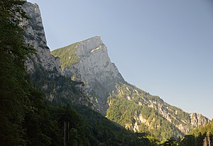
Planspitze from the east |
||
| height | 2117 m above sea level A. | |
| location | Styria , Austria | |
| Mountains | Gesäuse , Ennstal Alps | |
| Dominance | 0.8 km → Rosskuppe | |
| Notch height | 126 m ↓ Seescharte | |
| Coordinates | 47 ° 34 '24 " N , 14 ° 38' 24" E | |
|
|
||
| rock | Dachstein Limestone | |
| Age of the rock | Triad | |

The Planspitze ( 2117 m above sea level ) is a prominent peak in the Gesäuse , the northeastern part of the Ennstal Alps . It belongs to the Hochtor group and marks the beginning of the long ridge to the southwestern Hochtor and on to the Großer Ödstein . Like almost the entire Hochtor group, the Planspitze is also located in the Gesäuse National Park .
geology
The actual high gate chain is a mighty sequence of layers inclined towards the southeast. This collapse of the layers towards the south-east can be seen most clearly at the top of the plan. The huge north wall is formed by the layer heads, the much less steeply rising southeast area is formed by the flat layer surfaces. This structure should also have determined the name.
First slope
The first ascent of the Planspitze was made by unknown hunters, the first tourist ascent in August 1877 by Heinrich Heß , A. Heinzel and E. Gerstenberg from the Seescharte (1991 m) over the SSW flank ( I ), today's normal ascent.
The first ascent of the Petern Path was made by the poacher Andreas Peter Rodlauer, the Black Peter , before 1877. The first tourist ascent was made on June 11, 1877 Heinrich Hess with said guide Andreas Rodlauer.
The first known ascent of the waterfall path took place on July 5, 1877 by Heinrich Heß, T. Hansen, C. Sperl led by A. Rodlauer. At that time the waterfall path was not yet insured, the construction of the first climbing system did not take place until 1891 and 1892.
Routes to the summit
With a height of over 600 m and a width of over 1 km, the north face forms the imposing showpiece of the village of Gstatterboden . A large number of classic climbing tours lead through this wall. To the southeast, however, the Planspitze falls much flatter over lawn and craggy slopes into the Seekar.
It is therefore not surprising that the Planspitze is the easiest to climb from northeast to southwest, either from the Hesshütte over the Seescharte (SSW flank) or over the ONO flank, which can also be reached from the Hesshütte or directly from the Ennstal via the Wasserfallweg (Via ferrata difficulty B ) can be achieved. Surprisingly, the north face from the Haindlkar (from the Haindlkarhütte ) can be outwitted via the Peternpfad . The Peternpfad is a climbing tour of difficulty I-II , the most difficult part of which is the exposed Ennstaler step and which ends in the Peternscharte. From there the Seescharte and from it the summit can be climbed.
Most of the climbs through the north walls do not reach the summit directly, but end on the ridge somewhere next to the summit. Many routes are also terminated before the summit by crossing over the layer bands. The summit is reached, if at all, via the two easily climbed summit ridges.
Classic routes through the central part of the north face are:
- Inthaler-Kamin (guide Daniel Innthaler with Eduard Suchanek, July 1885), III +
- the north face ( Eduard Pichl , F. Panzer, June 10, 1900), II-III
- Lower west north pillar (K. Jilek, F. Schön, August 4, 1923), IV , and upper west north pillar (A. Deye, H. Feichtner, W. Ludwig, August 18, 1918), V- . This climb ends right at the summit.
- Entire north-west ridge pillar ( Klaus Hoi , Walter Almberger , May 27, 1979), VI-, A2, V +
literature
- Willi End : Gesäuse mountains. A guide for valleys, huts and mountains (= Alpine Club Guide. Nördliche Kalkalpen series. ). Bergverlag Rudolf Rother, Munich 1988, ISBN 3-7633-1248-X .

