Hammerbach (Mur)
|
Hammerbach Felsenbach |
||
|
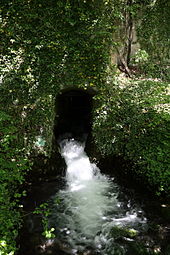
The Hammerbach at its confluence with the Mur |
||
| Data | ||
| location | Styria , Austria | |
| River system | Danube | |
| Drain over | Mur → Drava → Danube → Black Sea | |
| source |
Hammerbachquelle on the northeastern outskirts of Peggau 47 ° 12 ′ 35 ″ N , 15 ° 20 ′ 50 ″ E |
|
| Source height | 410 m above sea level A. | |
| Spring discharge |
NNQ (07/14/2002) MQ 1995–2011 HHQ (08/21/2005) |
42 l / s 187 l / s 1.623 m³ / s |
| muzzle | at the railway bridge in the Mur Coordinates: 47 ° 12 ′ 2 ″ N , 15 ° 20 ′ 40 ″ E 47 ° 12 ′ 2 ″ N , 15 ° 20 ′ 40 ″ E |
|
| Mouth height | 400 m above sea level A. | |
| Height difference | 10 m | |
| Bottom slope | 8.3 ‰ | |
| length | 1.2 km | |
| Catchment area | 21.65 km² | |
The Hammerbach , also called Felsenbach , is a left tributary of the Mur in Peggau in Styria .
geography
Hammerbachquelle
The Hammerbach rises from a karst spring at the foot of the Peggauer Wand, on the northeastern outskirts of Peggau. Under low water conditions, it is the only exit point of the complex Lurbach system, which also includes the Lurgrotten , the largest stalactite cave in Austria, located under the karstified Tannebenkalkstock .
The 6.5 km long Lurbach sinks into stream shrinkage on the plateau to the east near Semriach , flows through the Lurgrotten and emerges again at the origin of the Hammerbach. Only a pile of Hammerbach source higher than 200 liters per second, the seeping Lurbachwasser reached the north lying Schmelzbach source at the entrance portal of the Lurgrotte.
The catchment area extends over the entire Tannebenkalkstock. The source thus shows a mixture of surface water and karst water. The pouring of the Hammerbach spring varies greatly from 42 l / s to 1623 l / s with an average of 187 l / s (1995–2011 series). The productivity of the spring was used to operate hammer mills, which gave the emerging stream its name.
course
After its source, the Hammerbach runs south in the local area of Peggau, along the Alte Landstrasse. At Hammerbachstraße it bends to the southwest, crosses under the Brucker Schnellstraße and joins the Mur at the railway bridge after about 1.2 km from the left .
Individual evidence
- ↑ a b Federal Ministry of Agriculture, Forestry, Environment and Water Management (ed.): Hydrographisches Jahrbuch von Österreich 2011. 119th volume. Vienna 2013, p. Q73, PDF (12.9 MB) on bmlrt.gv.at (yearbook 2011)
- ↑ Google Earth
- ↑ BMLFUW (ed.) : List of areas of the Austrian river basins: Mur area. In: Contributions to Austria's Hydrography Issue No. 60, Vienna 2011, p. 72. PDF download , accessed on July 6, 2018.
- ↑ A better understanding of the Lurbach karst system through a conceptual precipitation-runoff model

